|
||

|

|
|

|
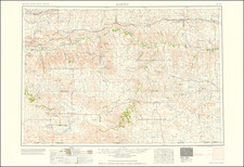
Sitting Bull and Standing Rock
Fine map of the Northern Plains, covering the Dakotas and large parts of Montana and Wyoming.
The map notes the location of Sitting Bull's camp along the Grand River in the Standing Rock Indian Reservation. All military forts and positions are underlined in overprinted red. In the year prior to the publication of the map, General Ruger ordered the capture of Chief Sitting Bull during the campaign to suppress the Ghost Dance movement. The action resulted in the death of the infamous chief and the entire Wounded Knee fiasco.
The map extends from Devil's Lake at upper right, west to the Four Buttes in the River - Crow Reservation and south of Hill City, and is filled with information including hundreds of place names, wagon roads, towns and settlements, numerous forts and camps, and extensive detail of the watershed.
The Standing Rock Agency, Cheyenne River, Pine Ridge, Rosebud, North Cheyenne, Fort Berthold, and Lower Brule Indian Reservations are identified. The railroad network is extensively covered.
![[ Wall Map of Montana Territory ] Map of the State of Montana. Compiled from the official Records of the General Land Office and other sources . . . 1897](https://storage.googleapis.com/raremaps/img/small/98232.jpg)

![A Hysterical Map Of The Yellowstone Park -- With Apologies To The Park -- Smileage Guaranteed [with mailer]](https://storage.googleapis.com/raremaps/img/small/87036.jpg)
![History of the Expedition under the Command of Captains Lewis and Clark, to the Sources of the Missouri Thence across the Rocky Mountains and Down the River Columbia to the Pacific Ocean, Performed During the Years 1804-5-6 [with map:] Map of Lewis and Clark's Track, Across the Western Portion of North America from the Mississippi to the Pacific Ocean](https://storage.googleapis.com/raremaps/img/small/92506.jpg)