


|
||

|

|
|

|
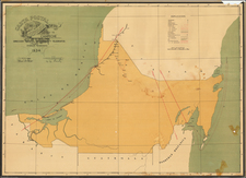
A mid-century map of Ensenada, Baja California del Norte. It shows the port of Todos Santos, the layout of the city and its neighborhoods, and plots of land not yet developed. The margins contain notes and tables showing how new plots should be labeled as well as showing the proprietors of various lots. This map was published by the city planning commission.
The early growth of Ensenada was shaky. It was destroyed during the Mexican Revolution and shedding its population until it eventually lost its status of territorial capital in 1915. Prohibition helped to restart the economy of Ensenada, bringing in an influx of American and Canadian tourists. This influx of tourist money helped to revitalize the area and the town was growing again by mid-century as a tourist destination for both Mexicans and Americans. Luxurious hotels sprang up, including the Hotel de La Riviera, portrayed on the map.
The map preserves the layout of off-axis street grids that we still see in the area from the Zona Centro to Play Ensenada (not yet developed). The streets and avenues mostly preserve their names to this day, allowing for easy identification of Avenida Ruiz and other notable areas. The one major change within the center of the city is that Arroyo Ensenada appears to be demarcated with plots of land, while in the present day it breaks the grid structure. In all, this is an attractive map of a popular tourist destination showing Ensenada as a coastal town and port before it became the large city we see today.
This map can be dated by cross-referencing the governor of Baja Norte stated in the map, Alfonso G. Gonzalez, who served from 1952 to 1953.

![(Mexican-Aztec Paintings) Facsimile, page 19 of an original [Mex]ican painting of Sir Thomas Bodley's collection [in the Bod]leian Library, Oxford, [Aglio's] Antiquities, vol. 1](https://storage.googleapis.com/raremaps/img/small/102328.jpg)