|
||

|

|
|

|
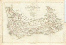
Fine map of the region explored by St. Vincent Erskine during his first exploration to the mouth of the Limpopo River, prepared to illustrate an article presented to the Royal Geographical Society in 1869.
St Vincent Whitshed Erskine (1846 - 1918) was the Surveyor General of South Africa. Erskine was an early explorer in Gazaland and was the first European to travel down the length of the Limpopo river to its mouth.
Erskine carried out a number of exploratory journeys in Southern Africa between 1868 and 1875 from Natal northwards into Gazaland and down to the mouth of the River Limpopo. Gazaland (modern day Mozambique and Zimbabwe extending northward from the Komati River at Delagoa Bay in Mozambique's Maputo Province to the Pungwe River in central Mozambique) records - “Probably the first European to penetrate any distance inland from the Sofala coast since the Portuguese gold-seekers of the 16th century was St. Vincent W. Erskine, who explored the region between the Limpopo and Pungwe (1868-1875).”
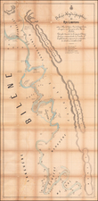
St Vincent Erskine's four journeys are reported in the Journal of the Royal Geographical Society, London:
- Journey of Exploration to the Mouth of the River Limpopo, By St Vincent W Erskine
- Journey to Umzila’s, South East Africa in 1871-1872. By Mr St Vincent Erskine, special Commissioner from the Natal government to Umzila, King of Gasa
- Two Journeys of Mr St Vincent Erskine in Gasa Land during the years 1873, 1874 and 1875
![[With Photos of an Early Owner!] Troye's Map of the Transvaal or S.A. Republic](https://storage.googleapis.com/raremaps/img/small/87453.jpg)