|
||

|

|
|

|
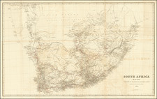
Early map of Southern Africa, illustrating the travels of George Thompson.
The map illustrates Thompson's route, the Mantatee track (indigenous people) and the boundaries of the colony.
Thompson was the author of a two-volume travelogue describing Travels and Adventures in South Africa in the years 1823–24. Thompson travelled to Cape Colony in 1818 and became a successful merchant in Cape Town. He travelled widely in southern Africa for purposes, expanding his company’s business among the early settlers of the Eastern Cape and elsewhere.
Later, Thompson travelled to Kuruman and to the Augrabies Falls on the Orange River. The second volume of Thompson's Travels and Adventures describes a journey to the ‘country of the Bushmen, Korannas, and Namaquas’, in the Roggeveld and Namaqualand and contains his observations on the settlers and indigenous people of those regions.
![[ First Modern Map of Southern Africa ] Tabula Moderna Secunde Porcionis Aphricae](https://storage.googleapis.com/raremaps/img/small/66800.jpg)
![[South Africa / Algoa Bay, Mossel Bay / Vleesbai ] The Bay of Algoa on the South Coast of Africa . . . | Plan of Mossel Bay on the South Coast of Africa . . . | Plan of Flesh Bay or Bay of St. Bras on The South Coast of Africa](https://storage.googleapis.com/raremaps/img/small/85695.jpg)