|
||

|

|
|

|
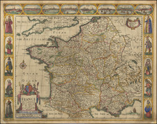
The First Map of France Printed North of the Alps
Based upon the work of the 2nd Century Alexandrian polymath Claudius Ptolemy, this map is perhaps the single most important and decorative map of the region printed in the 15th Century.
The map depicts Roman Gaul, based upon the coordinates and geographical information compiled by Ptolemy. The region is divided into Gallic provinces, including Aquitania, Celtogalatiia Belgica, Lugdunensis, and Narbonensis, and bounded by the river Rhine (“Renus flu.”), the Alps, and the Pyrenees. A number of islands appear in the Aquitanicum (Biscay Bay) and Mare Britannicum (English Channel), along with the outline of southern England (Albionis insule brittannice pars)
The most important site on the map appears as Templum Veneris on the Mediterranean Coast. This is Portus Veneris (Porte-Vendre) at the base of the Pyrenees, where Ptolemy shows the boundary of Narbonensis at the promontory on which stood the Aphrodisium or Temple of Venus (Templum Veneris), according to the reports of Pliny and Strabo.
The 1482 Ulm edition of Ptolemy's Geographia was the first edition printed north of the Alps map and the first to appear in color which was applied by the publisher. The 1482 Ulm edition of the Geographia was one of the most important cartographic texts of the early Renaissance and the first edition of the work to be printed outside Italy. The text for this edition was based upon a manuscript translated into Latin by Jacobus Angeli and edited by Nicolaus Germanus that had been brought to Ulm from Rome in 1468. The Ulm Ptolemy was first published in 1482 by Lienhart Holle, the same year as Berlingheri's Florence edition. Ashley Baynton Williams notes:
Working independently of Berlinghieri, but apparently using the same or similar models, Holle also added modern maps of Spain, France, Italy and Palestine, but also the first printed map of Scandinavia, composed by Cornelius Clavus, circa 1425-7 . Holle's maps were printed from woodcuts, and are characterised by heavy wash colouring for the sea areas, typically a rich blue for the 1482 edition, and an ochre for the 1486 edition. These bright colours, and the greater sense of age that woodcuts convey, make this series the most visually appealing of the [Ptolemaic] maps.
Holle went bankrupt shortly after the original publication and the work was taken over by Johann Reger, who issued a second edition in 1486.
Although the top margin has been trimmed away and reinstated in this example, we have seen other maps from the same atlas that confirm that there was no printed title above the maps, and therefore the map is from the 1482 edition.
Claudius Ptolemy (fl. AD 127-145) was an ancient geographer, astronomer, and mathematician. He is known today through translations and transcriptions of his work, but little is known about his life besides his residence in Alexandria.
Several of his works are still known today, although they have passed through several alterations and languages over the centuries. The Almagest, in thirteen books, discusses astronomy. It is in the Almagest that Ptolemy postulates his geocentric universe. His geometric ideas are contained in the Analemma, and his optical ideas were presented in five books known as the Optica.
His geographic and cartographic work was immensely influential. In the Planisphaerium, Ptolemy discusses the stereographic projection. Perhaps his best-known work is his Geographia, in eight books. However, Ptolemy’s ideas had been absent from western European intellectual history for roughly a thousand years, although Arab scholars interacted with his ideas from the ninth century onward.
In 1295, a Greek monk found a copy of Geographia in Constantinople; the emperor ordered a copy made and the Greek text began to circulate in eastern Europe. In 1393, a Byzantine diplomat brought a copy of the Geographia to Italy, where it was translated into Latin in 1406 and called the Cosmographia. The manuscript maps were first recorded in 1415. These manuscripts, of which there are over eighty extant today, are the descendants of Ptolemy’s work and a now-lost atlas consisting of a world map and 26 regional maps.
When Ptolemy’s work was re-introduced to Western scholarship, it proved radically influential for the understanding and appearance of maps. Ptolemy employs the concept of a graticule, uses latitude and longitude, and orients his maps to the north—concepts we take for granted today. The Geographia’s text is concerned with three main issues with regard to geography: the size and shape of the earth; map projection, i.e. how to represent the world’s curve proportionally on a plane surface; and the corruption of spatial data as it transfers from source to source. The text also contains instructions as to how to map the world on a globe or a plane surface, complete with the only set of geographic coordinates (8000 toponyms, 6400 with coordinates) to survive from the classical world.
![[Battle of Moncontou] Victoria di chatolici contra Hugonoti](https://storage.googleapis.com/raremaps/img/small/75053.jpg)