|
||

|

|
|

|
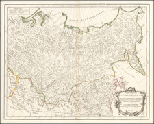
Fine Map of the Indian Ocean Basin, with Early Dutch Encounters with Australia
Nice example of Hugo Allard's rare and important map of Australia and the Indian Ocean. First issued in 1660, this example was re-issued by Hugo’s son, Carel.
The map covers the region from Australia and an exaggeratedly-large Van Diemens Land in the east to the Indian Ocean, Cape of Good Hope and the region around the Red Sea in the west. Much of the continents of Africa and Asia are included, as well as all of insular Southeast Asia. Japan is depicted in a horizontal position, a common depiction of the archipelago until the eighteenth century. Madagascar has a bend toward the east, another representation common to maps of this period.
New Guinea suggestively extends toward the north of Australia. It contains a label that explains that T. dos Papous was named New Guinea by Jacob le Maire. Le Maire and Willem Schouten led a commercial voyage that circumnavigated the world in 1615-1617. They discovered an alternative route to the Pacific by sailing around Cape Horn, as opposed to through the Strait of Magellan, and left Dutch place names all along the north coast of New Guinea and the surrounding islands, as seen here.
Allard could not know that Luís Vaz de Torres, who sailed with the Pacific explorer Pedro Fernandes de Quiros on a voyage for the Spanish in 1605, had passed through the straits between New Guinea and Australia. However, the Spanish had suppressed his report in the hopes of maintaining power via geographic secrecy and the Strait was only rediscovered by Alexander Dalrymple in 1762 when he was researching documents captured from the Spanish in the Philippines during the Seven Years’ War. Later, Cook sailed through the Strait, confirming its existence to the Western world, during his first voyage.
Allard maps are renowned for the decorative features. They typically contain a vignette that takes up much of the bottom edge of the print. Here, an ostrich hunt is reaching its climax, while turbaned merchants haggle over their wares near an elephant and a camel. Farther to the right, naked men are transporting small barrels. The image contains many European assumptions about the East: that it is has exotic animals, peoples, and goods.
Integrated into this scene is the title cartouche, where a cherub sits atop an ornate strapwork frame containing the title and Carel Allard’s signature. A small cartouche in the upper left has two putti pointing and playing with dividers; it houses the scale. At sea, European ships patrol the waters in search of spices and trade.
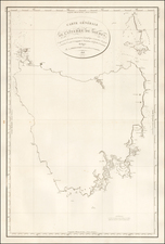
An early outline of Australia
As seen in the treatment of New Guinea, the Allards preferred to use Dutch sources for their maps when possible. They are known to have relied heavily on the Blaeus and Frederick de Wit as sources for their finely-engraved maps.
The Dutch not only made important contacts with New Guinea and the islands of Southeast Asia, but they were also some of the first Europeans to contact western Australia. Indeed, this map is noteworthy for its detailed depiction of the continent.
First, Allard has included the findings of Abel Tasman during his two voyages in the region from 1642 to 1644. They resulted in the first, albeit loose and broad, circumnavigation of Australia and the European discovery of Tasmania (Antoni van Diemen's landt), among other highly important findings in the region. As noted above, Van Diemen's Land it shown in too large a proportion to the rest of the Australian continent. Tasman’s own name is on a small island off the southeast coast of the feature.
On the mainland of Australia, here called Nova Hollandia and Terra del Zur, Allard includes a note saying that the northern portions were detected in 1644. This refers to Tasman’s second voyage, which charted the northern coast in detail in a large circle from Batavia, the eastern stronghold of the Dutch East India Company (VOC).
However, Dutch contact on the continent started four decades before Tasman sailed there. The first known European to land was Willem Janszoon on his voyage of 1605-6 in what is today Queensland. Janszoon was in command of the Duyfken, a Dutch East India Company (VOC) ship, and he explored the eastern shore of the Gulf of Carpentaria, just below the Cape York Peninsula. This venture was famously the first recorded European contact with Australia.
Interestingly, Allard makes no direct reference to the Duyfken. Nor does he call the northward extension of Australia Carpentaria, as it was then known. It was so named in 1623 by Jan Cartensz after Peiter de Carpentier, the VOC governor of the East Indies at that time.
Following the labels west in a counterclockwise direction, there are several earlier voyages that are mentioned by Allard. First is G F de Wits landt detecta Anno 1628. Gerrit Frederikszoon de Witt, captain of the Vianen, sailed in 1628, and ran aground near what is now Port Hedland. He managed to free his ship by offloading cargo and coasted southward.
Farther west is tLandt van d Eendracht 1616, followed by Dirck Hartogs ree. The Endracht was the second recorded European ship to contact Australia (1616), and the first in western Australia. The Endracht was blown off course en route to the East Indies in that year. It was commanded by Dirk Hartog, hence his name nearby. The crew commemorated their discovery by erecting a post with a pewter dish inscribed with their ship’s information—the earliest physical record that historians have of any European landing in Australia.
Farther south are the Houtman Abrolhas and the Tortelduyf, on an incomplete section of the coast. Jacob d’Edel, in the Amsterdam, along with Frederik de Houtman in the Dordrecht came within sight of the western coast in 1619. The Houtmans Abrolhos are an archipelago named for the navigator who sighted them, or at least it was Houtman who reported the islands to the VOC. The islands became infamous after the Batavia shipwrecked there in 1627. The mutiny and massacre that became Batavia’s fate fascinated all of Europe, but also flagged the islands as treacherous for ships, which is why they deserve such attention on charts. Also included is the shoal sighted by and named for the Tortelduyf in 1624.
Continuing south is I de Edels landt det 1619, a reference to land sighted by the Amsterdam and the Dordrecht above. Nearby is tLandt vande Leeuwin det 1622, a reference to the Leeuwin, whose crew charted some of the southwest coastline in 1622; British navigator Matthew Flinders would later name Cape Leeuwin, the southwestern most point on the Australian mainland, after the ship. A note in the south mentions Peter Nuyts, or Pieter Nuyts, a Dutch navigator who commanded the Gulden Zeepaert along the southern coast in 1627.
Finally, a non-Dutch contribution is also noted in this area. Off of the northwest coast of Australia is a tiny cluster of dots labeled Trial. This refers to another shipwreck, that of the Trial, an English East India Company ship. Commanded by Captain John Brookes, this was Australia’s first recorded shipwreck, in 1622. The ship ran into the reefs near what today are the Montebello Islands. 45 members of the crew managed to get to Batavia in two longboats, but many more crewmen were left behind.
Despite all of these encounters, European knowledge of Australia geography remained scattered and incomplete. It would not be until the late-eighteenth and early-nineteenth centuries that the Cook, Baudin and Flinders’ expeditions, among others, would provide detailed charts of the Australian coastline.
States and rarity
The map was first issued by Hugo Allard around 1660 and was later reissued by his son, Carel Allard. The only change in the states is the removal of Hugo’s name, which is replaced with Carel’s.
All Allard maps are relatively rare on the market, as their output was small. Their fine and distinctive style make them important examples of the cartography of the Dutch Golden Age.
Carel (Carol) Allard (Allardt) (1648–1709) was an engraver and publisher based in Amsterdam. Part of a prominent family of Dutch mapmakers, publishers, and print sellers, his father was engraver and publisher Hugo Allard (1627–1684), who left his business to Carel upon his death. Carel published anything in demand, including maps, topography, ethnography, newsprints, and restrikes of old plates of artistic prints, many of which likely came from his father’s stock. In 1706, Carel gave his copperplates to his son Abraham Allard, before going bankrupt.
![[ China ] Carte vom Reich China nach der neuesten grossen Carte des Herrn. d'Anville und Hase entworfen 1762](https://storage.googleapis.com/raremaps/img/small/103353.jpg)
![[ Myanmar ] A Map of the Burman Dominions, and Adjacent Countries, Compiled by John Walker, to accompany Mr. Crawfurd's Embassy to the Court of Ava.](https://storage.googleapis.com/raremaps/img/small/95995.jpg)
![[Shanghai to Nanjing] China Sheet IX Yang-Tse-Kiang From the Sea to Nanking Surveyed By Captns. C.R.D. Bethune H. Kellett & B Collinson, C.B. 1842.](https://storage.googleapis.com/raremaps/img/small/83103.jpg)