


|
||

|

|
|

|
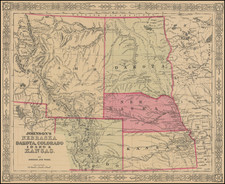
Rare 1859 edition of Charles Desilver's map of the region west of the Mississippi River to west of the Rocky Mountains, the first atlas map published in the United States to focus on this region.
Desilver's mid-continent map is a remarkably unique work for the time period. The map is rich with early immigrant information, Indian details, forts, roads, Indian Treaty notes, early explorers routes, Indian Battle grounds, Indian Reservations, trading posts and a host of other excellent notes and features. The map actually has its own symbol for trading posts, a rare appearance on a map of the period.
This map rarely appears on the market, as Desilver's atlas was not as widely distributed as others in the run, and this format appears not to have been included in all additions.
![[ Kansas ]](https://storage.googleapis.com/raremaps/img/small/100286.jpg)
![(Mexican War) [ Proposed United States - Mexico Military Border - January 1848 ]](https://storage.googleapis.com/raremaps/img/small/99246.jpg)
