|
||

|

|
|

|
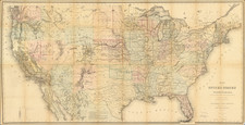
Scarce early map of the United States, published in Albany and engraved by G.W. Merchant.
The map extends to the Rocky Mountains, which are depicted in a simplistic fashion, but presents a compelling model of the hydrographical features in in Wyoming and Idaho which were utilized by Lewis & Clark.in their quest for a route from the Missouri River to the Pacific Ocean. The Rio Salado, Clark River, North Fork and South Fork of the Lewis River are the only rivers named west of the Rocky Mountains.
The massive area labeled Missouri Territory includes a number of Indian tribes and villages, but no other settlements.
Arkansas is shown in its "double wide" configuration, with Missouri and Louisiana the only states West of the Mississippi River.
Michigan Territory is now separated from Northwest Territory, but does not include the Upper Peninsula and includes only a few cities (Detroit, Monroe and unnamed City across from Ft. Malden.
Includes the area beyond Rio del Norte (Rio Grande), but the geography of Texas remains distorted and vacant for the most part. Locations and notations in Texas include Pass of Cavallo, Galveston Bay, I. of St. Luis, I. St. Fernando, Carancaways, Arcaquisas, the river system, and only a few interior towns, such as San Antonio. The Big Bend of the Rio Grande is reduced to a little bump.
Rarity
The map is scarce on the market.