


|
||

|

|
|

|
"One of the greatest monuments to the cartography of the American West."
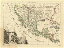
First state the highly important Preuss-Fremont map, the first map "to show the Oregon Trail accurately" (Rumsey).
William Reese describes the map as "One of the greatest monuments to the cartography of the American West."
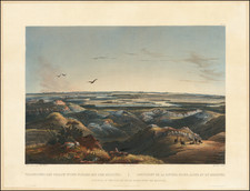
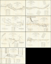
Charles Preuss was the official mapmaker who accompanied John Fremont's first and second expeditions and was responsible for the compilation of all of the maps which accompany Fremont's reports, including this highly important map of the Oregon Trail. Preuss's map, at a scale of ten miles to the inch, offered a remarkably accurate depiction of the Oregon Trail, tracing this important pioneer route from the Missouri River and the Columbia River.
Tracking the daily progress of the Fremont Expedition, from June 10, 1842, to October 26, 1843, Preuss's map shows the location of each encampment, as well as the noon-day halt of the expedition, and the total distance from the starting point at Westport Landing. Longitudinal and latitudinal coordinates are also given, as are daily "Meteorological Observations" and "Remarks," which include remarks on the availability of game, water, grazing, the hostility (or friendliness) of local Indian Tribes, and notes extracted from Fremont's Report.
As noted by Wheat:
More than any other persons, John Charles Fremont and Charles Preuss dominate the cartography of the American West during the three years before the gold rush...Owing to its rarity and to its long having stood in the shadow of the more widely known and distributed Fremont-Preuss map of 1845, Preuss' sectional map of 1846 has been insufficiently appreciated by students of Western history. In particular, those interested either in Fremont's travels in 1842-43 or the revolution of the transcontinental wagon roads will find that the map rewards close study.
The present example is the first state of the map, which is identical to the later issue, except that it includes the name of the lithographer (E. Weber).
An essential map for Western collectors.