


|
||

|

|
|

|
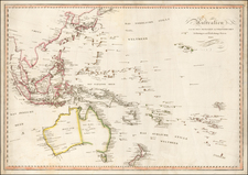
Remarkably detailed map of the Southe Pacific, extending from Hawaii and Maria Laxara in the NE to the Marquesas and the Islands around Tahiti in the SE, and extending to Australia, SE Asia and the Southern tip of Japan in the West. The map is remarkably detailed, with literally hundreds of islands named. Excellent detail throughout. The most curious feature is the reference to Notasie ou Nouvelle Hollande. We were unable to locate any other mapmaker who used this curious name. The reference to Polynesia is also one of the earlier apparances of the name on a commercially published map. The extensive exploration by the French in this region in the first part of the 19th Century is clearly in evidence. Beginning in the early 19th Century, Lapie was one of the leading French mapmakers, at a time when much of the great exploration and travel literature was being published in French. Lapie was often the engraver of maps which were included in these books. As a result, he often incorporated the most recent information and discoveries in his maps, often appearing prior to the official report from which the information derived. His maps are now prized for their detail, accuracy and attractive engraving style.
![[Hunter Island / Tasmania] Carte Trigonometrique des Iles Hunter dressee Par L. Freycinet, Commandant le Casuarina -- December 1802 (Rare Separately Published Example)](https://storage.googleapis.com/raremaps/img/small/53937.jpg)