|
||

|

|
|

|
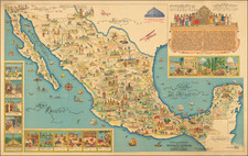
Fascinating pictorial map of the West Indies, "Prepared and Published By Pictorial Charts In Consultation With G.J. Cons, MA. . . . "
This informative pictorial map was prepared primarily to illustrate the agricultural production of the British West Indies. The grahics provide a fascinating period glimpse at British exploitation of the her colonies.
At the bottom, under the heading Planning For the Future, The virtues of the Anglo-American Commission, Caribbean Research Council and West Indian Conference are suggested with graphic vignettes, with a note
the Anglo-American Caribbean Commission was formed in 1942 to deal with the economic and social problems of the British and American colonies in the West Indies from a regional rather than a local standpoint.
The map was issued following the British and Americans entering into the Atlantic Charter. This was partly to show a kind of solidarity between fellow democracies but had clauses which would significantly impact political and economic events in the Caribbean. One clause stated that all people had a right to self-determination and a second clause effectively gave American companies access to British imperial markets.
The Americans were invited to form an Anglo-American Caribbean Commission from 1942 to re-examine the social situation in the light of the war getting in the way of the recommendations of the Royal Commission. America was increasing its influence over Britain's Caribbean colonies without taking on any of the burdens or responsibilities of governance. They were also gaining the market penetration and access they sought for companies like the American United Fruit Company or the Aluminum Company of America.
Rarity
The map is apparently unrecorded.
G.J. Cons was a senior lecturer ain geography at Goldsmith College, University of London and later head of the Geography and the author of Handbook for Geography Teachers. He also wrote The minimum that every schoolchild should learn. for Pictorial Quarterly, 1940.
In the Handbook for Geography Teachers , Cons note that the geographic outlook is ". . . truly focused on the interrelatedness of things." Cons asserts that geography links
the physical and the social sciences and states:
In the fusion of the sciences and humanities, geography is restoring the balance of the imagination and the analytical intellect of science. It is achieving a real synthesis between the two conceptions of culture, the humanistic and the scientific and thus it is helping to close the rift. . . .
Cons was a pioneer in pioneer in the field of geography films for schools and authored ‘Films and Living Geography’, Sight and Sound, 4/14 (Summer 1935)
The following is excerpted from Traces
A very different proposal comes from one of the few professional geographers involved in animated mapmaking for documentary films – G. J. Cons, who collaborated with the British Film Institute as scientific consultant for the production of educational documentaries. Referring to the series Indian Town Studies made by Gaumont-British Instructional, Cons highlights that ‘these films were made effective geographically by the use of animated maps’. It is evident that this effectiveness is based on the power of the trace since it allows a purely explanatory discourse which consists of the plain transmission of data and information even though no element really legitimises it. For him, there is little difference here between animated maps and informational images; the constitutive properties of motion and animation, whose consequences are far from being neutral, is relegated to a blurry allusion to a ‘living accurate’ vision. Does this prove the ineffectiveness of the attempt to acquire animated maps into the project of geography for ordering the world, or does it confirm Cons’ statement that ‘the genius of documentary film reveal[s] the screen as a magic casement through which our geographical vision of the Earth and its peoples is heightened’? In other terms, does the author’s faith in documentaries negate any concerns about the fabricated spectacle that animated maps present?
Apparently, and with a certain naivety, Cons seems to advocate a perfect analogy between the map, the mirror, and the screen – a position that may surprise coming from a professional geographer. However, as explained by Priya Jaikumar in an insightful essay on the series, the result is not the faithful and plain reproduction of Cons claims but rather an attestation of the role of animated maps in the building of that ideology that put together positivist, modernist, and colonial contents: ‘[t]owns in India were visualised to make them intelligible and transparent, with vision transforming a place, its people and fullness of their lives, into abstract space.’ Again, thanks also to the power of the trace the pretensions of correct visualisation and geographical accuracy have been overthrown and transformed into something completely different: the colonial fiction of mastery and control through alleged scientific instruments used in narrative and visual devices for making this very same fiction true.
Giuseppe Fidotta: Animated maps and the power of the trace. 'Traces' Spring 2014

![[Cambodia] Defend the People's Victory | Support the Khmer Rouge & the PRG](https://storage.googleapis.com/raremaps/img/small/85958.jpg)