


|
||

|

|
|

|
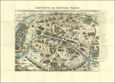
Rare wall map of Paris, issued at the beginning of the 19th Century, several decades before the major projects to re-design Paris under Georges-Eugène Haussmann commenced planning.
The map divides Paris nto 12 arrondissements and 48 districts, published in the year before the Bourbon restoration. The map illustrates the he first works of embellishment and development of roads which had been ordered by Napoleon, including:
- Canal de l'Ourcq, completed in 1802
- Canal de Saint-Denis, begun in 1811
- Bassin de la Villette, intended to supply the capital, completed between 1806 and 1809
- Abattoirs
- cemeteries of the North, East, from Vaugirard, from Sainte-Catherine (decree of June 12, 1804)
- new Morgue place du Marché-Neuf (police order of 1804)
- Pont des Arts, built between 1802 and 1804
- Pont d'Austerlitz, between 1799 and 1807
- Reserve granaries
- Quai d'Orsay
- flower market
- western part of the rue de Rivoli.
On the right bank, facing the Champ de Mars, is the drawing of a "projected palace". This is the Villa Trocadéro, a project by the architect Antoine-François Peyre, which was never carried out.
Around the plan were arranged 29 views of the main Parisian monuments, including the "projected palace" of the villa Trocadéro.
Rarity
The map is scarce. The present example, dated 1814, woiuld seem to be the first edition of the map, which was re-issued in 1815 and 1816.
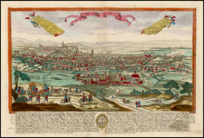

![[ Saint-Denis ] Pourtraict de la Ville de Sainct Denis en France](https://storage.googleapis.com/raremaps/img/small/74991.jpg)
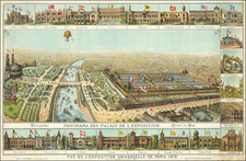
![[ Paris ] Le Nouveau Plan de Paris Dresse sur le Memoires de Mr. Jouvin de Rochefort Tresorier de France, Corrige, Augmente, et Enrichi de Veues de Versailles Situees aux Environs Dresees sur le Lieux.](https://storage.googleapis.com/raremaps/img/small/103832.jpg)