This item has been sold, but you can enter your email address to be notified if another example becomes available.


|
||

|

|
|

|
Stock# 65460
Description
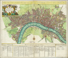
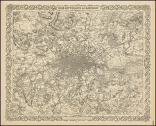
Rare two-sheet (joined as one) map of London at the end of the 18th century, published by Bowles & Carver in London in 1795.
The map shows London as it was about to burst into the countryside and takeover the surrounding farmland. The whole map is laid on a number-letter grid, which with the use of the table of references gives the names of major landmarks, churches, etc.
In the long note on London at the bottom of the map there is a table describing the coaches and ferries and what times they run.
Condition Description
Two sheets. A short mended tear in the upper right corner of the righthand sheet.
Reference
Howgego 71.3
![(London) [Eyewitness Watercolor Drawing of the Burning of Her Majesty's Theatre, Covent Garden, on December 6, 1867.]](https://storage.googleapis.com/raremaps/img/small/90852.jpg)