|
||

|

|
|

|
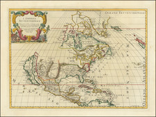
Rare map of North America, based upon Guillaume De L'Isle's seminal map of North America, published in 1700 in Paris.
Extremely Rare First State of De L'Isle's Highly Important Map of North America
De L'Isle's map is a widely celebrated cartographic landmark. Because of De L'Isle's access to the information from French explorers in the New World at a time when the French dominated the explorations of the interior of the continent, De L'Isle's maps were invariably updated and innovative in their content.
De L'Isle's map was a foundation map. The Great Lakes based on Coronelli show the French strong points at Tadousac, Quebec, Fort Sorel, Montreal & Fort Frontenac. the English settlements confined to the east of the Alleghenies, with Fort and River Kinibeki as the border between New England and Acadia. The Mississippi valley area is shown well developed with the recent French settlement of d'Iberville at Bilochy and forts at Bon Secours and St. Louis.
Perhaps most significantly, the map was the first to show the mouth of the Mississippi is accurately shown for the first time, being the first map to depict information from the surveys of the D'Iberville expedition.
The present example is an elegant reduction, and quite rare on the market.

![[ First State of the First Map of America ] Novae Insulae XVII Nova Tabula](https://storage.googleapis.com/raremaps/img/small/94609.jpg)