|
||

|

|
|

|
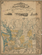
Original 1932 Edition!
Fine pictorial map of the Oregon Trail..
Artist William Forsyth McIlwraith was noted for his historic illustrations including work for the Works Project Administration (WPA), in particular the Oregon Public Works of Art program.
The handsome bird's eye view style map covers the expanse from Westport in the east to the Pacific coast, with the Rocky Mountains, major forts and missions, etc. pictured, along with herds of buffalo, and the title covering the distance: "From Westport, now Kansas City by way of Forts Kearney, Laramie, Bridger, Hall and Boise, also the Sublette and Lander Cutoffs, and the Bozeman and Applegate Trails and the Overland Trail to the Sacramento Valley and the California Gold Mines."
The pictorial border depicts people of historical interest to the history of the North West, with a freize of wagon trains and the state seals forming the upper and lower border.
Rarity
The 1932 edition of the map is quite scarce. Most examples that appear on the market are the reproduction done by Binfords & Mort in 1980 (credit line at the bottom right, below the neatline).
![[ Southern Railroads ] Railroad Map of the Southern States Shewing the Southern & Southwestern Railway Connections With Philadelphia. 1862 . . . Prepared by Thomas Kimber Jr., Chairman of the Committee on Inland Transportation of the Board of Trade of Philadelphia](https://storage.googleapis.com/raremaps/img/small/103211.jpg)