


|
||

|

|
|

|
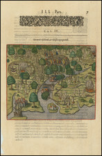
Striking old color example of the Johannes Blaeu edition of Barleus' map of a portion of Brazil, which first appeared in Barleus's from his ervm per Octennivm in Brasilia et alibi nuper gesterum sub Praefectura Illustrissimi Comitis I. Mavritii, Nassoviae, &c…published by Blaeu in 1647.
This spectacular map of the Brazilian coastline covers the capitanias of Paraiba and Rio Grande. The map was drawn after actual surveys by Georg Markgraf, Elias Herckmanns and others, and was among the first maps of Brazil based on non-Portuguese data.
The map is richly engraved with a huge scene of a procession of Tupinamba Indians carrying a French flag, part of a sugar mill, and 3 major sea battles depicted in the sea. Includes a coats of arms, a compass rose and strapwork title cartouche.
Blaeu first issued this and its companion maps in 1647 for Gaspar Barleus' Rerum per octennium in Brasilia. They were also assembled into a large wall map, Brasilia qua parte paret Belgis; the places where the sheets overlapped are marked by faint lines at left. The maps then appeared in the Atlas Maior beginning in 1662. This example is oriented with west at the top and extends from Rio Grande to the Captaincy of Paraiba, depicting a number of sea battles fought in 1640. This series of maps is one of the most coveted of all Brazilian maps from the 17th Century.
Joan, or Johannes, Blaeu (1596-1673) was the son of Willem Janszoon Blaeu. He inherited his father’s meticulous and striking mapmaking style and continued the Blaeu workshop until it burned in 1672. Initially, Joan trained as a lawyer, but he decided to join his father’s business rather than practice.
After his father’s death in 1638, Joan and his brother, Cornelis, took over their father’s shop and Joan took on his work as hydrographer to the Dutch East India Company. Joan brought out many important works, including Nova et Accuratissima Terrarum Orbis Tabula, a world map to commemorate the Peace of Westphalia which brought news of Abel Tasman’s voyages in the Pacific to the attention of Europe. This map was used as a template for the world map set in the floor of the Amsterdam Town Hall, the Groote Burger-Zaal, in 1655.
Joan also modified and greatly expanded his father’s Atlas novus, first published in 1635. All the while, Joan was honing his own atlas. He published the Atlas maior between 1662 and 1672. It is one of the most sought-after atlases by collectors and institutions today due to the attention to the detail, quality, and beauty of the maps. He is also known for his town plans and wall maps of the continents. Joan’s productivity slammed to a halt in 1672, when a fire completely destroyed his workshop and stock. Joan died a year later and is buried in the Westerkerk in Amsterdam.
![[ Porto Calvo ] Eroberung der Vestung Povacon zu Porto Calvo in Brasilia, durch Graff Joh. Mauritz van Nassau General in Brasilien, im Febuario und Mario Anno 1637 . . .](https://storage.googleapis.com/raremaps/img/small/0325gh.jpg)
![[Ilha da Santa Catarina to Bombinhas]](https://storage.googleapis.com/raremaps/img/small/59595.jpg)
