This item has been sold, but you can enter your email address to be notified if another example becomes available.


|
||

|

|
|

|
Stock# 65353
Description
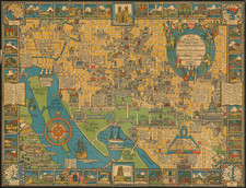
Nuclear War Evacuation Routes During The Cold War
1959 Office of Civil and Defense Mobilization map of Washington, D.C., published during the Cold War.
The map extends from Falls Church and Springfield, Virginia to District Heights and Randolph Village, Maryland. The map illustrates the civil authority's evacuation plan in the event of a nuclear strike, with the evacuation routes are overprinted through the city in red ink. Arrows along these routes indicate the direction of traffic flow.
Three different boundaries show the direction in which the evacuees were to travel.
This map was created by the Office of Civil and Defense Mobilization and printed by the Government Printing Office in 1959.
![(Second World War - Postwar Reconstruction) [Archive of Materials Related to American Reconstruction Efforts in Bavaria]](https://storage.googleapis.com/raremaps/img/small/88055.jpg)