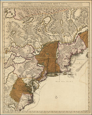


|
||

|

|
|

|
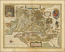
Nice example of Henricus Hondius' derivative of John Smith's highly important 1612 map of Virginia.
Hondius's map of the Chesapeake region was one of the first maps engraved by Henricus for his Atlantis Appendix of 1630. It is the only edition of the map where the Indian faces the Chesapeake. A nice example, with no text on the verso.
As noted by Burden, John Smith's map is "one of the most important printed maps of America ever published and certainly one of the greatest influence. It became the prototype for the area for half a century." Burden goes so far as to say that the map's publication considerably influenced the success of the Virginia Colony itself.
In 1606, the London Company sent its first ship to Virginia and established the Jamestown settlement. Captain John Smith accompanied the English settlers at Jamestown. Between 1607 and 1609, he explored the major rivers which flowed west into the Chesapeake Bay, recording the names of the Native American villages and tribes he encountered. The limits of Smith's explorations are marked with a Maltese cross. Beyond the crosses, Smith relied on Native American accounts to delineate territories further upriver. Smith notes on the map, "To the crosses hath bin discouerd what beyond is by relation."
Smith's depiction of the Native America villages and accounts of the region is one of the primary sources for information on the region in the early 17h Century. Burden notes that "to this day the map is still used by archaeologists to locate native Indian villages. It records 166 of them and is remarkably detailed." The illustrations of Powhatan's Council and Native are derived from the original drawings of John White.
Upon Smith's return to England in 1609, Smith employed William Hole to engrave a map, which was first included in a small pamphlet by Joseph Barnes, of Oxford, in 1612. The map would not appear again for 12 years, when it was included, along with Smith's map of New England, in his landmark work, The Generall Historie of Virginia, New-England and the Summer Isles, in 1624. The following year it was included in Purchas His Pilgrimes.
Smith's map was by far the most important map of Virginia published in the first part of the 17th century. First issued in 1612, it became the prototype map of the region until Augustine Hermann's map of 1673. The map depicts a number of explorations and observations of Smith and the Jamestown settlers. There is some question as to whether the map is the work of Smith, who led most of the explorations, or the surveyor accompanying him, Nathaniel Powell. However, convention attributes the map to John Smith as his name appears on it in two publications by him and in a third by Samuel Purchas, who credits Smith with the production of the map.
The map became the prototype for the mapping of the region for the next 60 years, being copied by a number of mapmakers until the 1670s.
Henricus Hondius (1597-1651) was a Dutch engraver and mapmaker, a member of a prominent cartographic family. His father, Jodocus Hondius, was also an engraver and geographer. While working with his father, Henricus was instrumental in the expansion and republishing of Mercator’s atlas, first published in 1595 and republished by Hondius in 1606.
Upon his father’s death in 1612, Henricus and his brother, Jodocus the Younger, took over the business. He set up his own shop in 1621, where he continued to release new editions of the Mercator atlas. Later, he partnered with his brother-in-law, Jan Janssonius, in continuing to expand and publish Mercator’s atlas, which would become known as the Mercator-Hondius-Janssonius atlas. Born and based in Amsterdam, he died there in 1651.
![[ Port Royal, South Carolina ]](https://storage.googleapis.com/raremaps/img/small/81298.jpg)
![[Jefferson's Notes on the State of Virginia] Observations sur la Virginie [with the map:] A Map of the country between Albemarle Sound, and Lake Erie, comprehending the whole of Virginia, Maryland, Delaware, and Pensylvania, with parts of several other of the United States of America. Engraved for the Notes on Virginia.](https://storage.googleapis.com/raremaps/img/small/51828.jpg)

![(Carolinas) Virginiae Partis australis, et Floridae partis orientalis, interjacentiumqus regionum Nova Descriptio [A New Description of the Southern Part of Virginia and the Eastern Part of Florida, and the Intervening Regions.]](https://storage.googleapis.com/raremaps/img/small/94131.jpg)