|
||

|

|
|

|
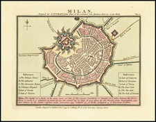
Modern Milan -- With Architectural Facades of Major Buildings Illustrated
Rare map of Milan, published in Milan in 1868, in the style of the maps of Paris of the time, embellished with vignettes of major buildings.
Sold in the shop of the Ronchi Establishment, located in the new Galleria Vittorio Emanuele II, this fine map appeared in several editions, beginning in about 1865.
The map provides a fine overview of the city, divided according to the Mandamenti of the city and includes a detailed key showing the names, addresses and coordinates of the "primary establishments". Places of worship no longer appear, but administrative offices, archives schools and colleges, libraries, commercial institutions, theaters, assistance institutes, barracks and military commands.
The map also includes descriptive text describing the function of the Milanese gates as customs barriers.
Overall, the information on the map is intended to convey the sense of an urban modernity that is identified with its secular and administrative organization, differentiating it from earlier maps of Milan. The map is embellished with topographical and architectural features, including facades of numerous private neoclassical buildings; the Lazzaretto, cut in two by the railway overpass; the Arena flooded for a show of naumachia which is perhaps a legacy of a previous iconography; the meticulous indication of greenery, especially regarding the public gardens of Porta Venezia, completed around 1862, where the paths, the water system and the new Caffè building.
Rarity
The plan is apparently quite Rare. OCLC locates 1 example of a circa 1865 edition (Bibliotheque National de France) and 1 example of the 1870 edition (Boston Public Library).
We note also a copy of the 1869 edition in the Civica Raccolta delle Stampe Achille Bertarelli, Milano (Civic Collection of Prints Achille Bertarelli, Milan).

![Magnifica Illa Civitas Verona [and] Colonia Augusta Verona Nova Gallieniana](https://storage.googleapis.com/raremaps/img/small/85818.jpg)
![[Brixen, Italy and Lauingen, German] Brixia Tyrolis [and] Laubinga Sveviae](https://storage.googleapis.com/raremaps/img/small/76740.jpg)
![[Pavia] Pavie](https://storage.googleapis.com/raremaps/img/small/77325.jpg)