The item illustrated and described below is sold, but we
have another example in stock. To view the example which
is currently being offered for sale, click the
"View Details" button below.


|
||

|

|
|

|
Stock# 6532
Description
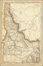
One of the earliest separately issued maps of Idaho to appear in a Commecial Atlas. Highly detailed, showing towns, mines, roads, railroads, mountains, rivers, Indian Reservations, military reserves, post offices, forts, lakes, etc. Remarkably detailed. Colored by county. From the earliest obtainable edition of Rand McNally's Indexed Atlas, preceded only by extremely rare Business Atlas editions.
![[Geology Map of the Texas, California & the Southwest] Esquisse Geologique Des Anciennes Possessions Mexicains Du Nord Incorporees Ala Federation des Etats-Unis . . . 1867](https://storage.googleapis.com/raremaps/img/small/71446.jpg)
![[Troops in the Mountains of North America] Nordamericanische Truppen auf einem Gebirgszug](https://storage.googleapis.com/raremaps/img/small/91333.jpg)