


|
||

|

|
|

|
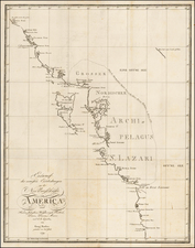
Promoting The Newest Alaskan Mining Regions
Rare promotional map and brochure, printed for the North American Transportation and Trading Company to Nome and St. Michael.
The map provides a large depiction of Alaska and the Klondike Region, with gold regions noted in red, along with the route of the North American Transportation and Trading Company. The "All American Route" from Valdez is shown on both the main map and the 40 Mile District Inset.
First issued in 1900, this 1902 edition adds the inset map of the Chitanika District. This is an early reference to Chatanika, a mining settlement established about 1904, which received a railroad station when the Tanana Valley Railroad was completed in 1907. The Chatanika post office was established in 1908. Chatanika was one of over a dozen small communities in the vicinity of Fairbanks whose prosperity was tied to gold mining during the Fairbanks Gold Rush. Chatanika, along with Fox, are the only two of the numerous communities in the hills immediately north of Fairbanks which has managed to remain populated and maintain a distinct community identity.
In addition to the main map, two photographs show interior images of the Dining Saloons on the Ocean Steamship "Roanoke" and the Yukon River Steamer "John Cudahy," along with inset maps focusing on the mining regions of:
- Chitanika District
- Forty Mile Creek
- Birch Creek District
- Klondike Section
- Sumner Peninsula
The verso includes promotional information encouraging the trip to Alaska.
Rarity
The map is very rare. OCLC notes copies at the University of Washington, Yale and Dartmouth.
We find no prior auction or dealer catalog records.
![Amer. Sep. No. 24. Nouveau Cornouailles [Prince Rupert, Babine Lake &c]](https://storage.googleapis.com/raremaps/img/small/1783RB.jpg)