


|
||

|

|
|

|
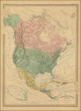
Interesting map of North America, published in Augsburg by Walch.
The map illustrates North America shortly after the dissemination of the discoveries of Lewis & Clark, with "Clarke's" River clearly depicted on the map in the region called Columbiathal. The Multhomah River also makes and early appearance on this map.
In the mid-Continent, a number of Indian Tribes are shown in the Louisiana region, which had just become of part of America. The boundary between Louisiana and New Mexico does not yet reflect the boundary set by the United States and Spain in the Adams Onis Treaty.
The configuration of Alaska is interesting.
Johann, or Johannes, Walch (1757-1816) was a painter and engraver. He was well-known for painting miniature portraits, having trained in Geneva, Venice, and Rome. Walch published several atlases and sheet maps. As with his atlases, many of Walch’s maps were reprinted after his death.


![Amerique Septentrionale divisee en Ses Principales parties . . . . 1674 [Rare First State]](https://storage.googleapis.com/raremaps/img/small/99317.jpg)
![A Map of North America, Constructed According To The Latest Information: by H.S. Tanner. Improved to 1825 [Case Map]](https://storage.googleapis.com/raremaps/img/small/68580.jpg)