|
||

|

|
|

|
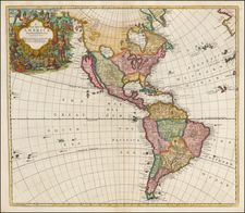
Interesting map of America from the first part of the 19th Century.
Mexico, Texas and Upper California are still part of New Spain.
The coastline of the Northwest part of America is well delineated, following the expeditions of Vancouver, La Perouse and other explorers and is now becoming an area where fur trading and whaling is beginning to take hold. but the exploration in search of the Northwest Passage is still 4 decades from discovering a water route from the Atlantic to the Pacific.
Coming 4 years after the Official Account of Lewis & Clark, the Pacific Northwest waterways and topography is beginning to take shape.
Johann, or Johannes, Walch (1757-1816) was a painter and engraver. He was well-known for painting miniature portraits, having trained in Geneva, Venice, and Rome. Walch published several atlases and sheet maps. As with his atlases, many of Walch’s maps were reprinted after his death.