|
||

|

|
|

|
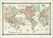
Spreading the Gospel -- Republic of Texas!
Fine large map of the world, published by the British & Foreign Bible Society and emphasizing the society's efforts to spread the gospel around the world.
The map emphasizes the non-Christian populations of the various shaded regions around the world, with an eye toward the visualization of non-Christian populations and Brirtish efforts to evangelize across the globe in the first half of the 19th Century.
Curiously, the map delineates Texas as a Republic, although the population given (7,500,000) is almost certainly for all of Mexico's non-Christian indigenous residents.
At the bottom right, a key explains the society's work "Distributing, Printing or Translating of the Scriptiures" directly into 67 Languages & Dialects and Indirectly into 68 Languages & Dialects, including 105 "translations never before printed." A total of 22,288,706 bibles were apparently distribute by the Society as of March 1841, at a cost of nearly 2,800,000 pounds sterling.
A second key, to the left of the first, breaks down the bible societies in the UK and "Colonies and other Dependencies", with a total of 2,636 societies counted. At bottom center, a color key identifies the colors used on the map:
- Christianity / Roman Catholic: light orange
- Christianity / Protestant: pink
- Christianity / Greek Church: green
- Mohmmedanism: blue
- Paganism: blue/grey
Across the bottom, the distribution of bibles around the world is given by region and sub-regions, including:
- Russia
- Persia
- India
- Central India
- Indo Chinese
- Chinese Empire
- Hither Polynesia
- Further Polynesia
- Africa
- Nth America
- Sth America
- Western Europe
- Eastern Europe
- Northern Europe
- Central Europe
As noted in The Church of England quarterly review at page 551-52 (1839)
This map is one of the most splendid undertakings of the present day, and is not only fitted to show how far the influence of the British and Foreign Bible Service has prevailed over the world, but is adapted to numberless purposes in literature. It gives, at one view, the outline of Klaproth's and Balbi's labours, and is an excellent synopsis of the latest of Adelung's Mirthridates. The comparative prevalence of Christianity, Mohammedanism, and Paganism is easily seen, and the various dialects which ar used in large countries are accurately marked; thus to the theologian, the philologer, adn the student of statistics, its power of assistance is self-evident. It is beautifully executed, and reflects great credit ton Mr. Wyld.
British and Foreign Bible Society
The British and Foreign Bible Society (BFBS) dates back to 1804 when a group of Christians ( including William Wilberforce and Thomas Charles), associated with the Religious Tract Society, sought to address the problem of a lack of affordable Bibles in Welsh for Welsh-speaking Christians. Many young girls had walked long distances to Rev Thomas Charles to get copies of the Bible. Later the story was told of one of them - a young girl called Mary Jones who walked over 20 miles to get a Bible in Bala, Gwynedd.
The first BFBS translation project was the Gospel of John into Mohawk for Canada. In the British Isles BFBS reprinted Bibles in Welsh, Scots Gaelic and Manx Gaelic first produced by SPCK. The first Romani translation was the Gospel of Luke into the Caló language of Iberia.
From the early days, the Society sought to be ecumenical and non-sectarian. The Controversy in 1825–26 about the Apocrypha and the Metrical Psalms resulted in the secession of the Glasgow and Edinburgh Bible Societies, which later formed what is now the Scottish Bible Society. This and another similar 1831 controversy about Unitarians holding significant Society offices resulted in a minority separating to form the Trinitarian Bible Society.
The Bible Society extended its work to England, India, Europe and beyond. Protestant communities in many European countries (such as Croatia and Albania) date back to the work of nineteenth-century BFBS Bible salesmen. Auxiliary branches were set up all over the world, which later became Bible Societies in their own right, and today operate in co-operation as part of the United Bible Societies.
Rarity
The map is extremely rare. OCLC locates 1 example of the first state of the map (British Library) and 3 later states (Cambridge, Glasgow and the University of Greifswald).
We locate no other examples offered for sale or at auction in any recorded source.
James Wyld Sr. (1790-1836) was a British cartographer and one of Europe’s leading mapmakers. He made many contributions to cartography, including the introduction of lithography into map printing in 1812.
William Faden, another celebrated cartographer, passed down his mapmaking business to Wyld in 1823. The quality and quantity of Faden’s maps, combined with Wyld’s considerable skill, brought Wyld great prestige.
Wyld was named geographer to Kings George IV and William IV, as well as HRH the Duke of York. In 1825, he was elected an Associate of the Institution of Civil Engineers. He was one of the founding members of the Royal Geographical Society in 1830. Also in 1830, his son, James Wyld Jr., took over his publishing house. Wyld Sr. died of overwork on October 14, 1836.
James Wyld Jr. (1812-87) was a renowned cartographer in his own right and he successfully carried on his father’s business. He gained the title of Geographer to the Queen and H.R.H. Prince Albert. Punch (1850) described him in humorous cartographic terms, “If Mr. Wyld’s brain should be ever discovered (we will be bound he has a Map of it inside his hat), we should like to have a peep at it, for we have a suspicion that the two hemispheres must be printed, varnished, and glazed, exactly like a pair of globes.”
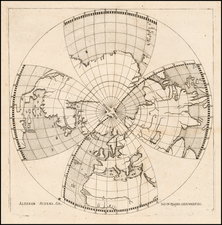
![(World - First State!) Benedict Arias Montanus Sacrae Geographiae Tabulam ex Antiquissimorum Cultor. [Pre-Dutch Discovery Depiction of Australia]](https://storage.googleapis.com/raremaps/img/small/93232.jpg)
![[Mussolini Celebrates Pearl Harbor] Grande Carta Del Pacifico](https://storage.googleapis.com/raremaps/img/small/65273.jpg)