|
||

|

|
|

|
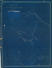
Early Depiction of Washington Railroads
Fine map of Washington Territory published by the Government Land Office, emphasizing the existing and planned railroad lines of the Northern Pacific Railroad.
In the Straits of Juan de Fuca, details concerning the establishment of the boundary between the US and Canada are shown, including the details of the Treaty and Executive Orders establishing the border. Similarly, the dates of the treaties establishing the various Indian Reservations are given.
While the townships surveys are well on their way to completion, there are still extensive unsurveyed regions.
The lines of several early railroads are given, including a key with extensive information on the progress of the Northern Pacific Railroad.
The General Land Office (GLO) refers to the independent agency in the United States that was in charge of public domain lands. Created in 1812, it assumed the responsibilities for public domain lands from the United States Department of the Treasury. The Treasury had overseen the survey of the Northwest Territory, but as more area was added to the United States, a new agency was necessary to survey the new lands.
Eventually, the GLO would be responsible for the surveying, platting, and sale of the majority of the land west of the Mississippi, with the exception of Texas. When the Secretary of the Interior was created in 1849, the GLO was placed under its authority. Until the creation of the Forest Service in 1905, the GLO also managed forest lands that had been removed from public domain. In additional to managing the fees and sales of land, the GLO produced maps and plans of the areas and plots they surveyed. In 1946, the GLO merged with the United States Grazing Service to become the Bureau of Land Management.

![[Alaska to San Diego and San Qunitin, British Columbia] A Chart Shewing Part of the Coast of N.W. America, with the Tracks of His Majesty's Sloop Discovery and Armed Tender Chatham . . . (First Modern Map of the West Coast of North America)](https://storage.googleapis.com/raremaps/img/small/102067.jpg)