


|
||

|

|
|

|
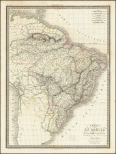
Striking map of Brazil, Bolivia, Upper Peru, Paraguay and Uruguay, at the close of the colonial period. Shows towns, roads, rivers, lakes, mountains, islands, bays, points, etc. Fascinating hachuring style to represent the various mountains and river valleys. Terrific detail in the interior. One of the best maps of Brazil during the period. One of the earliest obtainable maps of Brazil following its independence. Beginning in the early 19th Century, Lapie was one of the leading French mapmakers, at a time when much of the great exploration and travel literature was being published in French. Lapie was often the engraver of maps which were included in these books. As a result, he often incorporated the most recent information and discoveries in his maps, often appearing prior to the official report from which the information derived. His maps are now prized for their detail, accuracy and attractive engraving style.
![ПОЛИТИЧЕСКАЯ КАРТА ЮЖНОЙ АМЕРИКИ. [Political Map of South America]](https://storage.googleapis.com/raremaps/img/small/90259.jpg)