|
||

|

|
|

|
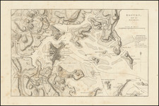
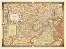
Sailing Into Boston Harbor During The American Revolution
Large aquatint and engraved sheet with four profile views of Boston, which were published by J.F.W. Des Barres, which appeared in his Atlantice Neptune.
This sheet of views would have used by navigators approaching Boston during the Revolution, to accompany the sailing directions and chart of Boston Harbor also created by Des Barres. The views include:
- Boston, as seen between Castle Williams and Governors Island, distant 4 miles
- Appearance of the High Lands of Agamenticus, N.E. with Penobscot Hills, to the Eastwards, at 3 to 4 Leagues off Shore
- Boston Bay, the Light House bearing N.W. b. W. distant one League
- The Entrance of Boston Harbor
The Atlantic Neptune
The chart was issued in The Atlantic Neptune, an atlas of North American waters published in London by J.F.W. Des Barres and used by British navigators throughout the American Revolution. The charts were of an extraordinarily high quality, remained the standard for decades, and were often copied and reissued by American and European engravers and publishers.
Copies of the Neptune were apparently made up to order, and new charts, maps and views were being produced throughout the Revolutionary years, and there was thus no standard collation. The most complete versions extended to five volumes, covering in turn Nova Scotia, New England, the River and Gulf of St. Lawrence (based on the work of James Cook), the coast south of New York, and American coastal views. The volumes integrated nautical charts, recognition views and sailing directions to provide seamen with multiple, (hopefully) complementary data sets for navigating the often difficult waters off the East Coast and Gulf of Mexico.
Joseph Frederick Wallet Des Barres (1721-1824) was born in either Paris or Basel, Switzerland, to a Hugueont family. He studied under the great mathematician Daniel Bernoulli at the University of Basel before immigrating to Britain, where he trained at the Royal Military College, Woolwich.
Upon the outbreak of hostilities with France in 1756, he joined the British Royal American Regiment as a military engineer. He came to the attention of General James Wolfe, who was impressed with his charting ability. During this period, he also worked with the legendary future explorer, James Cook, on a monumental chart of the St. Lawrence River.
Des Barres is best known for the Atlantic Neptune, was a remarkable, multi-volume set of sea charts and coastal views prepared from recent surveys, some of which were overseen by Des Barres in Nova Scotia after the Seven Years’ War. The maps, charts, and views were prepared under the supervision of Des Barres and employed as many as twenty engravers and assistants. They were produced over the course of a decade, from 1774 to 1784, in time to be used by the Royal Navy in the American Revolution.
After the Revolution, Loyalists were resettled throughout Canada. As part of this process, a new colony was created by separating Cape Breton from Nova Scotia. Des Barres, who already owned extensive lands in the Maritimes, served as lieutenant governor of Cape Breton Island from 1784 to 1787. He later served as governor of Prince Edward Island from 1804-1812.
Des Barres lived an exceptionally long life, even by today's standards, finally dying at age 102. Des Barres' funeral was held at St. George's Round Church in 1824 and he is buried in Halifax.
![[Revolutionary War Plans of New York, Boston, Charleston, Delaware River to Philadelphia & Havana] Various Plans and Draughts of Cities, Towns, Harbours &c . . .](https://storage.googleapis.com/raremaps/img/small/83450.jpg)