


|
||

|

|
|

|
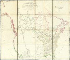
Rare Early 1830 Tanner Map of the United States
Rare large map of the United States by Tanner, published in 1830.
The map provides a fine post-Adams-Onis Treaty treatment of the United States, with only two states (Louisiana and Missouri) and one Territory (Arkansas) shown west of the Mississippi River.
The west is dominated by several large Indian Districts (Sioux, Mandana, Ozark, Osage) and Oregon District.
Texas is Coahuila and Texas. Further west is Santa Fe Territory, Sonora, and Upper California, which includes several mythical rivers and lakes.
The mapping of Oregon reflects the knowledge of Lewis & Clark and the overland expeditions to Astoria and Fur Traders who followed them into the region.
The Rocky Mountains include a section called Oregon or Rocky Mounts.
![[ Shows Colona ] Map of the United States and Mexico. Published . . . Under the Direction of Col. Carlos Butterfield. December 1859](https://storage.googleapis.com/raremaps/img/small/103272.jpg)
![[ Rotary Club International ] USCB Districts of Rotary International as of 1 July, 1958](https://storage.googleapis.com/raremaps/img/small/90418.jpg)