The item illustrated and described below is sold, but we
have another example in stock. To view the example which
is currently being offered for sale, click the
"View Details" button below.
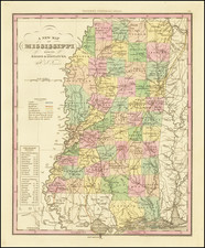
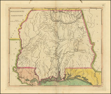
1836 Henry Schenk Tanner
$ 195.00


|
||

|

|
|

|
Stock# 65098
Description
Fine example of Tanner's map of Mississippi, from the first edition of Tanner's Universal Atlas.
This example of the map was first issued in 1836. It is hand colored by counties, and shows towns, roads with distances, railroads, steamship routes, and a host of other details.
One of the best early atlas maps of Mississippi, with still primitive counties in the Northwest.
![[ Mississippi ] Carte Geographique, Statistique Et Historique Du Mississippi](https://storage.googleapis.com/raremaps/img/small/76150.jpg)
![[Louisiana / British Emigration -- 5 Maps] Land District North of the Red River in the State of Louisiana / District North of the Red River Louisiana / Land District North of the Red River, State of Louisiana / Township 20 N. Range 13 East, Land District North of the Red River in the State of Louisiana / A Map, exhibiting the order oft he Surveys of the Public Lands of the United States of North America . . . .](https://storage.googleapis.com/raremaps/img/small/90084.jpg)