|
||

|

|
|

|
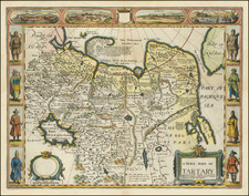
Scarce Valk & Schenk edition of Jan Jansson's highly decorative map of northeastern China and Korea.
The present map is very geographically advanced for its time and depicts the provinces of Hebei (Pecheli), Shanxi (Xansi), Shandong (Xantung), Henan (Honan), and Jangsu (Nanking). A legend identifies cities and towns of various sizes, forts, as well as mines for gold and iron. The massive Great Wall of China forms the northern border and the important salt flats are graphically illustrated along the coast. Beijing assumes the name Xuntien and Shanghai is named Sungkiang.
The title cartouche is of the very distinct auricular style favored in the contemporary Netherlands, and is flanked by Chinese Mandarins. The other cartouche, containing the scale of miles, is surrounded by putti. Three ships sail in the sea between China and Corea (Korea), which is noted as being a peninsula.
The map is based on the groundbreaking work of Martino Martini (1614-61), a legendary Italian Jesuit missionary and scholar. Martini arrived in Beijing in 1644 just as the Ming Dynasty fell to the Manchurian rebels (who formed the Qing Dynasty).
Following in the footsteps of his fellow Italian Jesuit Mateo Ricci, Martini sought out the very best maps and surveys of the Chinese Empire. He compiled a series of maps that were by far the most accurate depictions of China to date.
Martini's suite of 17 maps was first published by Joan Blaeu as the Novus Atlas Sinensis, which accounted for volume 10 of his Atlas Maior (Amsterdam 1655). The present edition of one of the most important maps was issued shortly thereafter by Blaeu's rival Jan Jansson. Martini's work was described by the great German geographer Ferdinand von Richthofen, as:
"the most complete geographical description of China that we possess, and through which Martini has become the father of geographical learning on China."
Indeed, even Jean-Baptiste du Halde's Description…de la Chine (Paris, 1735), published 80 years later, did not fully supersede Martini's work.
Peter Schenk the Elder (1660-1711) moved to Amsterdam in 1675 and began to learn the art of mezzotint. In 1694 he bought some of the copperplate stock of the mapmaker Johannes Janssonius, which allowed him to specialize in the engraving and printing of maps and prints. He split his time between his Amsterdam shop and Leipzig and also sold a considerable volume of materials to London.
Peter Schenk the Elder had three sons. Peter the Younger carried on his father’s business in Leipzig while the other two, Leonard and Jan, worked in Amsterdam. Leonard engraved several maps and also carried on his father’s relationship with engraving plates for the Amsterdam edition of the Histoire de l'Académie Royale des Sciences.
Gerard Valk, or Gerrit Leendertsz Valck (1652-1726) together with his son Leonard, were the only significant publishers of globes in the Netherlands in the eighteenth century, enjoying an almost total monopoly in the first half of the 1700's. Initially an engraver and art dealer, and having worked for map-sellers Christopher Browne and David Loggan in London between 1672 and 1679, Valk established the firm in Amsterdam in 1687. Initially, they published maps and atlases, but in 1700 the company moved the shop to the building previously occupied by map and globe-maker Jodocus Hondius. In 1701, he applied for a charter for making globes and the "Planetolabium", designed by Lotharius Zumbach de Coesfelt (1661-1727), an astronomy lecturer at Leiden University. The Valks produced several editions of 3, 6, 9, 12, 15, 18 and 24-inch diameter terrestrial and celestial globes. The cartography, as stated on the cartouche, is based closely on the celestial atlas Uranographia, published in 1687 by the celebrated Polish astronomer Johannes Hevelius (1611-1687).
Around 1711, when he became a member of the bookseller's guild, Leonard Valk (1675-1746) came into partnership and his name started to appear alongside that of his father on the cartouches of the globes, although the earliest of these, both terrestrial and celestial, still bear the date 1700. Leonard naturally took over the business on his father's death in 1726, and following his own death in 1746 the firm was run by Maria Valk, cousin, and wife to Gerard. By then its days of glory had passed. Leonard Valk died in relative poverty: his wife had to take in the washing of their aunt to make ends meet. The late eighteenth century saw a number of successful reissues by publisher Cornelis Covens (1764-1825), who ran the famous cartographical publishing house of Covens & Mortier (1721-1866) in Amsterdam. This firm was the biggest Dutch one for publishing maps in the 18th century. It was located on the Vijgendam (Fig Dam), the southern part of what is now Dam Square, the central hub of the city. They didn't move out of their building, but they did change addresses. At first in 1795 the whole Dam was rebaptized into Revolution Square, then it got the name Napoleon Square, till in 1813 after Napoleon's fall Covens & Mortier were back again at the Vijgendam.
![Plan du Typa ou de Macao [with] Plan De La Baye D'Awatwska…Du Kamtschatka [with] Parti Du Japon ou Nipon](https://storage.googleapis.com/raremaps/img/small/36150.jpg)