|
||

|

|
|

|
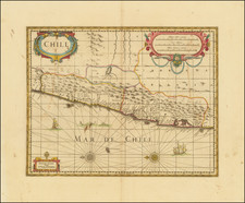
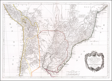
Rare early map of the province of Chile, locating rivers and settlements, the earliest map to include information from the previously secret manuscript maps of the Spanish cosmographer, Juan López de Velasco.
The map first appeared in Herrera's Descripcion de las Indias Ocidentales, first published in Madrid in 1601.
Herrera's map is one of the earliest maps to show the region and one of the most unique, coming exclusively from Spanish sources.
As is typical of Spanish maps published prior to 1750, because of the official Spanish policy of secrecy concerning their Colonies, there is very little detail provided with respect to topography, places and town names. The work depicts China, Japan, The Philippines, the northern coast of New Guinea and the Salomon Islands.
Herrera served as the official historian of the King of Spain, and he produced a substantial history of the West Indies, Central and South America. Originally published in 1601 in Madrid, it was reissued later in several editions and languages.