|
||

|

|
|

|
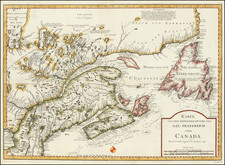
Scarce French & Indian War map of the Eastern US, w/in set of Georgia and South Carolina, from Anderson's Collection of Voyages. The map is clearly based upon DeVaugondy's map issued in 1755. This english version is quite scarce and has provided dealers with great consternation over the years. In researching the map, we noted attributions to Kitchen, Hogg, Anonymous and others, just in the past 10 years, and dates varying from 1758 to 1795. A scarce desireable map from a hard to find English compilation of voyages published in the latter part of the 18th Century and depicting the US during the French and Indian War. Virginia, and the Carolinas extend to the Mississippi River. Ohio is named, but far from becoming an independent territory. Many Indian Place name, forts, towns, rivers, mountains, etc. located. A nice example of this scarce map.
Alexander Hogg was a publisher active in London from 1778 to 1824. He worked under the sign of the Kings Arms on Paternoster Row. He is especially known for publishing architectural and historical prints, as well as maps.
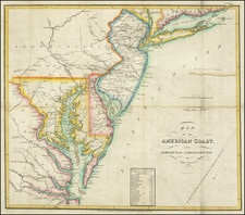
![[ Cape Hatteras to New York City ] The Coast of the United States of North America; from New York to St. Augustine: Drawn and regulated according to the latest Surveys and Astronomical Observations By Edmund Blunt. Additions to 1839 & 1840](https://storage.googleapis.com/raremaps/img/small/84684.jpg)