
This item has been sold, but you can enter your email address to be notified if another example becomes available.


|
||

|

|
|

|
Stock# 64938op
Description
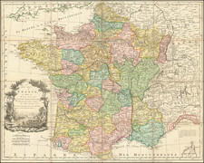
Detailed railroad and postal map of France from the 1860s.
The map differentiates between operating railroads and those that are in construction or had been granted concessions.
The map illustrates the State, Department, and Arrondissement. Special Customs Zones are marked in green.
Condition Description
Dissected in 45 sections and mounted on original linen. House in contemporary marbled paper case.
![(France under Clovis) Franciae Status sub Regibus Primae Stirpis, ex Observationibus D. Mart. Bouquet Benedictini atque ex Dissertationibus D. Lebeuf Canonici Autis . . . [The State of France under its First Kings. . .]](https://storage.googleapis.com/raremaps/img/small/89714.jpg)
![[English Channel] A New Gradnally Encreassnig Compass-map of the Comingin of the Channel, or the Heads; containing a part of the coast of Boulonnois; extending from Callis to Dannes, as also in England, from the South Foreland to Rye; with their S'hallownesses and Depths By N. deVries](https://storage.googleapis.com/raremaps/img/small/85127.jpg)
![(Classical France) Tercia Europe Tabula [Third Map of Europe]](https://storage.googleapis.com/raremaps/img/small/101895.jpg)
![[ France and Low Countries ] Totius galliae descriptio, cum parte Angliae, Germaniae, Flandriae, Brabantiae, Italiae, Romam usque](https://storage.googleapis.com/raremaps/img/small/74214.jpg)
![[ Holy Roman Empire, Poland, Baltic, etc. ] Germania VI Nova Tabula (First state!)](https://storage.googleapis.com/raremaps/img/small/94645.jpg)