


|
||

|

|
|

|
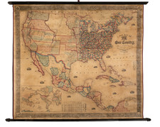
Alexis de Tocqueville's map of the American Democracy
Nice example of the first edition of Alexis De Tocqueville's map of North America.
The map provides a simplified picture of the United States, showing the existing states, populations and the year each was admitted to the Union. There are also some notes regarding the early history of America, including Plymouth and Jamestown.
The area in modern Texas and Oklahoma is noted as "Limits of the Great Desert inhabited only by Buffalos, Wild Horses, and a few wandering Tribes of Indians." In addition, two lines are noted, a line showing the northernmost growing limits for corn, and a north-south continental divide, with respect to the directions in which the rivers flow.
The remarks below the title include two notes regarding the population of Whites and Blacks in the slave and non-slave states. The map as issued just one year after the abolition of slavery in Britain.
Alexis-Charles-Henri Clérel de Tocqueville was a French political thinker and historian best known for his Democracy in America, wherein he examined the rising living standards and social conditions of individuals and their relationship to the market and state in Western societies.
In Democracy in America, Tocqueville wrote about Democracy. Observing from the perspective of a detached social scientist, Tocqueville wrote of his travels through America in the early 19th century when the market revolution, Western expansion, and Jacksonian democracy were radically transforming the fabric of American life.
![(North America) ФИЗИЧЕСКАЯ КАРТА СEВЕРНОЙ АМЕРИКИ. [Physical Map of North America]](https://storage.googleapis.com/raremaps/img/small/90262.jpg)
![[ United States ] Etats-Unis de l'Amerique](https://storage.googleapis.com/raremaps/img/small/98821.jpg)