|
||

|

|
|

|
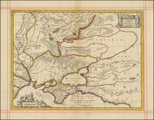
Rare ethnographic map of the Russian territory of which is the modern Republic of Armenia
The region is a mostly Christian area that (partially) became a part of Russian Empire in 1828 and after early XXth century turmoil and mass murders became part of the Soviet Union. Armenia got it’s independence the USSR in 1991.
This map is important piece of evidence illustating the ethnic makeup of the region prior to the ethnic genocide in Armenia. It shows the ethnical situation in Armenia right after the massive relocation of Armenians after the Russian-Turkish war in 1878 but before the massive genocide begun during the WWI.
The map shows 7 ethnicities – Russians, Tatars, Greeks, Kurds, Armenians, Aisors (Assyrians).
The map appeared in rare Kavkazskiy Kalendar’ (The Caucasian Calendar) in late 1890’s
The author of the maps and the data, lieutenant-general Elisey Isidorovich Kondratenko (died 1906), was a prominent Russian researcher and politician. Among other titles he held, Kondratenko was the Head of Caucasian department of the Russian Geographic Society. The map is from the ethnographic studies of Zakavkazskiy kray region from his study Etnograficheskie karty guberniy i oblastey Zakavkazskogo kraya originally published with a separate atlas (the atlas held 7 plates) in 1893. Kondratenko also was the editor-in-chief of the Kavkazsky Kalendar’ where he published those maps for those who were unable to obtain a copy of his 1893 study. Those are the first detailed ethnographic maps of the Caucasian region ever.
The data on those maps was made using the information from family lists from each settlement. This data was given to him by State censor and Head of the Caucasian statistical committee Nikolai Zeidliz - who acquired it via his connections in Russian state police (it means that the most of the data used in those maps is barely illegal) and who made the first general Caucasian ethnographic map in 1880. Because of sources, the data was more accurate and differed from the official statistics of region’ cameral descriptions.
![[ Finland - Theater of War ] Theatre de la Guerre en Finlande Pour l'Intelligence des Mouvements des Troupes Suedoises et Moscovites . .. 1742](https://storage.googleapis.com/raremaps/img/small/95511.jpg)