


|
||

|

|
|

|
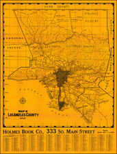
One of the First Separately Published Maps of Southern California
Fine large format map of Southern California, published in San Francisco by Willson & Co. and printed by Galloway Litho Co. of San Francisco.
The map extends a little north of San Luis Obispo, east to the Colorado River and south to Mexico, capturing all of what we now consider Southern California.
The map shows town, railroads, wagon roads, drainage, transportation lines, ranchos, townships, and mining districts, as well as altitudes of selected points and temperature and rainfall figures.
Among the more interesting features are the identification of roughly 200 Ranchos and Private Land Grants.
The concept of Southern California as a geographical region did not exist until the 1880s and even those maps tended to focus on the region within 100 miles of the coast, rather than extending all the way to the Colorado River.
Rarity
OCLC lists 4 examples (University of Minnesota, Huntington Library, and University of California Berkeley (2 examples).
![[ Pacific Northwest - Northwest Passage ] Limes Occidentis Quivira et Anian. 1597](https://storage.googleapis.com/raremaps/img/small/71207.jpg)

![[Los Angeles] Metro Greenline](https://storage.googleapis.com/raremaps/img/small/96817.jpg)