


|
||

|

|
|

|
With Early Airplanes and Hot Air Balloon and Early Dirigible
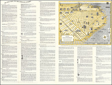
Rare panoramic view of the proposed site of the Panama Pacific International Exposition, published by The Owl Drug Company.
The image provides an interesting Bird's-eye view of site of planned fair, looking south, with features labeled. The scale of the view is distorted to highlight the location of the Exposition, Harbor View, Lincoln Park, Golden Gate Park and the Presidio.
Other features noted on the map include The Civic Center, Customs House, Telegraph Hill, The Merchant Exchange, Civic Center, Ferry Building, Stadium in Golden Gate Park and a number of Hotels.
An "Intermural Rail Road Station" in the Presidio is shown.
Images of Early Flight in San Francisco
Perhaps the most interesting feature on the map is the presence of several airplanes between the Presidio and Harbor View and an early dirigible off the coast near Seal Rock.
The first airplane to fly in San Francisco was in late January 1910, when French pilot Louis Paulhan flew a Farman Biplane over the city, watched by a crowd of more than 30,000 gathered in and around the San Francisco horse racing track, paid for by the San Francisco Chronicle.
An earlier attempt to fly was made by San Francisco resident Daniel Maloney, using a glider-type “aeronaut” lifted by hot air balloons to 5,000 feet, then dropped above a Santa Clara field on July 18, 1905, which ended in disaster.
Rarity
We locate a single example of the map in the California Historical Society.
![[San Francisco] A cartograph of Treasure Island in San Francisco Bay Golden Gate International Exposition](https://storage.googleapis.com/raremaps/img/small/92375.jpg)