


|
||

|

|
|

|
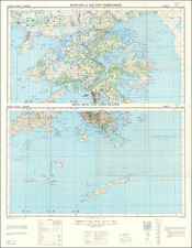
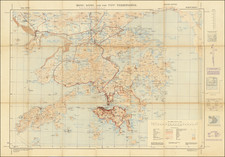
Early bilingual map of the so-called New Towns of Hong Kong, which were developed in the middle of the 20th century to accommodate the city's burgeoning population.
This map features the first three major New Towns (Tuen Mun, Tsuen Wan, and Sha Tin) and three smaller New Towns (Yuen Long, Sheung Shui, and Tai Po).
In Hong Kong, the first phase of new town development was unveiled in 1973, including Tsuen Wan New Town, which as a satellite town was not brought to full-scale development, and also Sha Tin New Town and Tuen Mun New Town. These new towns were intended to accommodate a few hundred thousand people each. For example, according to the first plan in 1961, the government planned to accommodate 360,000 people in Sha Tin once the entire new town had been built; the estimated population in Sha Tin rose to 500,000 in the planning of the early 1970s. In the corresponding areas land was reclaimed to create new space for some of the new towns. These newly developed towns, maturing in the 1980s, provided new homes to more than 1 million Hong Kong people.
![[Ladrone Islands / Wanshan Archipelago] Ladronen Chine](https://storage.googleapis.com/raremaps/img/small/90221.jpg)

![[China] 古今地舆全圖 / Full Modern and Ancient Map](https://storage.googleapis.com/raremaps/img/small/62437kb.jpg)