|
||

|

|
|

|
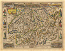
Antique Willem Janszoon Blaeu map of the Canton of Grisons, the largest and easternmost Canton of Switzerland.
The map shows the towns and cities of the mountainous region, including Davos and St. Moritz.
Beautiful cartouche at the upper right with coats of arms and allegorical figures depicting the area as the font of the Rhine and Inn Rivers.
Shows the north end of Lago di Como at the bottom of the map.
Willem Janszoon Blaeu (1571-1638) was a prominent Dutch geographer and publisher. Born the son of a herring merchant, Blaeu chose not fish but mathematics and astronomy for his focus. He studied with the famous Danish astronomer Tycho Brahe, with whom he honed his instrument and globe making skills. Blaeu set up shop in Amsterdam, where he sold instruments and globes, published maps, and edited the works of intellectuals like Descartes and Hugo Grotius. In 1635, he released his atlas, Theatrum Orbis Terrarum, sive, Atlas novus.
Willem died in 1638. He had two sons, Cornelis (1610-1648) and Joan (1596-1673). Joan trained as a lawyer, but joined his father’s business rather than practice. After his father’s death, the brothers took over their father’s shop and Joan took on his work as hydrographer to the Dutch East India Company. Later in life, Joan would modify and greatly expand his father’s Atlas novus, eventually releasing his masterpiece, the Atlas maior, between 1662 and 1672.
![[Geneva] Jenff](https://storage.googleapis.com/raremaps/img/small/89152.jpg)
![Nova Rhaetiae atq[ue] totius Helvetiae descriptio per Aegidium Tschudum Glaronensem](https://storage.googleapis.com/raremaps/img/small/80319.jpg)
![[ Bern, Switzerland ] Inclytae Urbis et Ditionis Bernensis cum locis finitimis Tabula Geographica et Hydrographica noviter correcta](https://storage.googleapis.com/raremaps/img/small/99812.jpg)