


|
||

|

|
|

|
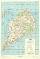
"SECRET" Situation Map of Iwo Jima Detailing the Minutiae of the Japanese Defense of the Island.
A rare “Secret” situation map of Iwo Jima prepared in anticipation of the February 19, 1945 U.S. invasion of the island. The map shows the landing zones on the southeastern and southwestern beaches of the island, and, most importantly, the Japanese defensive installations throughout the island in minute detail… at least as they were known to American forces before the battle.
Background
Iwo Jima, whose name translates as “Sulfur Island,” was an important midway point between South Pacific bomber bases that were already in the hands of the Allies and the Japanese home islands. 700 miles from Tokyo and 350 from the nearest U.S. airbase, with a central plain suitable for building large runways, American planners viewed it as a valuable target. The battle for the island was among the bloodiest of the Pacific Theater of the Second World War. In total, more than 6,800 U.S. Marines lost their lives and more than 19,000 were wounded, while a staggering 18,000 of the roughly 20,000 Japanese defenders were killed. In light of these terrible losses, there was, and still is, dispute about whether the invasion had been merited:
As early as April 1945, retired Chief of Naval Operations William V. Pratt stated in Newsweek magazine that considering the “expenditure of manpower to acquire a small, God-forsaken island, useless to the Army as a staging base and useless to the Navy as a fleet base ... [one] wonders if the same sort of airbase could not have been reached by acquiring other strategic localities at lower cost. (“Battle of Iwo Jima,” at Wikipedia.com)
Production and Compilation of the Map
Offered here is a rare map of Iwo Jima, which would have provided planners and troops on the ground with a staggering amount of information about the natural and man-made landscape. Contours are given at 20-foot intervals, symbols indicate bluffs and terraces, and the mapmakers seem to have attempted to indicate every dwelling and other civilian structure on the island. Most strikingly, more than 30 distinct symbols are used
to indicate different elements of the Japanese defenses, including for example eight distinct types of gun (from machine guns to heavy artillery), range finders, rifle pits, air raid shelters, searchlights, radio towers, &c, &c. Superimposed on the whole is a detailed grid of numbered “1000-yard target areas” and lettered “200-yard target squares.” These, or later iterations thereof, would have guided the pre-invasion bombardment that attempted to blanket the entire island, though ultimately with insufficient effect, as well as the use of artillery to support ground troops after the landing.
Several notations below the map indicate the complex, multi-layered effort required to produce it. Starting with a 1943 base map, in September 1944 the 1633rd Engineering Photomapping Platoon used aerial reconnaissance photos taken over the past month to add contour lines. Then in November other units (the AC of S,G2 Fleet Marine Force, Pacific and Intelligence Section[,] Amphibious Forces Pacific, to be precise) used reconnaissance photos taken as late as October 15 to compile the Japanese “installations.” The 64th Engineering Topographical Battalion is also credited, though other than printing the map its contribution is not clear. The final product is dated November 1944, three months before the invasion began on February 19, 1945. Thus, if the map was in fact used for pre-invasion planning or during the battle itself, it was likely out of date.
Indeed, for all the sophistication of the American intelligence effort and the resulting maps such as the one offered here, the results were disastrous. American planners failed to understand the defensive strategy of Japanese General Kurabayashi or the complexity and extent of the Japanese fortifications, which included a huge network of linked underground bunkers, well-hidden and -protected artillery positions, interlocking fields of fire, and some 11 miles of tunnels. They also vastly overestimated the impact of the months-long pre-invasion bombardment, which left these fortifications largely intact on the day of the invasion. Indeed, one recent writer quotes Admiral Chester Nimitz, American Commander-in-Chief, Pacific, as having said “Well, this will be easy. The Japanese will surrender Iwo Jima without a fight.” (Derrick Wright, The Battle for Iwo Jima, p. 51)
Additional Material
The map is accompanied by a 32-page pamphlet titled “Home Addresses of 3921 ST Sig Svc Co,” with the front and rear cover bearing a pictorial map of Iwo Jima, clearly including some inside jokes. There is also a 5-page typed letter, dated “Iwo Jima October 17th ” and signed only “Marion.” This is likely the Marion H. Pfluger (1921-2009) of Pflugerville, Texas listed in the address book. An obituary describes Pfluger’s service during the Battle of Iwo Jima as follows:
In 1945, six days after the initial invasion of Iwo Jima, Marion and his four comrades found themselves in a foxhole with their communication equipment. This was their "base" for six weeks. It was their job to code and decode messages including decoding Japanese messages. After the battle was won, these five guys remained on Iwo Jimo for thirteen more months living in a tent at the foot of Mount Surabachi. (Austin [Texas] American Statesman for March 15, 2009)
Written nearly a half year after the end of the battle, the first half of the latter is mostly chatty, but the latter pages are devoted to a harrowing account of a fire and explosion at an ammunition dump on his base. A lifelong golfer, after Pluger’s military service he starred in the sport at the University of Texas, then spent much of his career as a golf pro in Colorado, where this material was found at an estate sale by its previous owner.
Rarity
No copies located in OCLC. We do locate another example at the Museum of Fine Arts, Houston, marked up to indicate the progress of the battle on the northwest part of the island. This firm has in recent years sold two similar maps--though hardly identical—one of which was marked up to indicate day-by-day progress over several weeks of thebattle.
Appendix: Defensive Installations
The Defense Symbol Key elaborates an impressive number of defensive installations.
- Coastal Defense Gun
- Dual Mount Dual Purpose Gun
- Dual Purpose Gun Position (Empty)
- Single Mount Heavy AA
- Automatic AA
- Covered Artillery Emplacement
- Range Finder
- Unidentified Installation
- R.D.F.
- Rifle Pit or Fox Hole
- Mast or Tower
- Underground Entrance
- Air Raid Shelter
- Anti-Tank Gun
- Water Storage
- Machine Gun
- Blockhouse
- Pillbox
- Radar
- Searchlight
- Command Post
- Observation Tower
- Anti-Tank Barrier
- Radio Station
- Radio Tower
- Anti-Boat Barrier
- Open Artillery Emplacement
- Anti-Tank Trench
- Empty Revetment
- Ammunition Storage
- Fire Trench
- Short Sections of Anti-Tank Trench
- Barbed Wire
- Earth Covered Structure
- "Dotted Symbols Indicate Possible Installations".
HOME ADDRESSES a 32-page mimeograph pamphlet, staple-bound; highly-acidic paper, with some chips, fold separations and tears. TLS 5pp, signed in pencil and stapled at upper left, excellent.
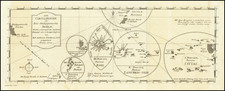
![[Japan] Carte Des Decouvertes au Nord du Japon Faites en 1643 par les Vaisseaux Hollandais le Kastrkum et le Breskens, Comprenant la Terre de Jeso, I'Ile des Etats et la Terre de Compagnie, dont partie a ete reconnue en 1787 . . .](https://storage.googleapis.com/raremaps/img/small/49803.jpg)