|
||

|

|
|

|
Munsell's Monumental 1834 Map of the Commonwealth of Kentucky -- An Elegant Ornament for the Study or the Parlor
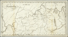
Nice example of Luke Munsell's rare four sheet map of Kentucky, first published in 1834. The map is the second of Munsell's wall maps of Kentucky, providing a substantially revised, updated and improved version of his monumental map of 1818 and clearly delineating the roughly 350 mile border between Kentucky and Tennessee.
Hand colored by counties, the 1834 Munsell map locates towns, roads, rivers, topographical features and other fine details. It also includes insets of the towns of Louisville, Frankfort, Lexington and Maysville, as well as two statistical tables, a comparative chart of the major rivers in Kentucky, a profile view of the Railroad from Lexington to Frankfort and images of Canal locks for the Louisville and Portland Canal. Most importantly, the map is the first graphic depiction of Kentucky following the 14 year struggle by Kentucky and Tennesee to set down a fair and scientifically precise border between the two states, involving numerous regional surveys, interpretations of prior survey results, and consultation with local residents impacted by the legal and political implications of the placement of the line. Ironically, the most interesting local deviations are not yet shown, including one which took into account the concerns of local citizens who did not want to illegally sell locally distilled spirits across state lines!
Defining the Border 1765 to 1819
Defining the border between the two states dates back to June 30, 1665, when Charles I of England granted to the Earl of Clarendon a section of land between Carolina and Virginia at 36° 30", running from the Atlantic Ocean to the South Sea (Pacific Ocean).
In 1728, two groups of surveyors and commissioners from the colonies of Virginia and North Carolina surveyed approximately 237 miles of the boundary, until they reached Peter's Creek in the western Piedmont.
In 1749, the Fry and Jefferson Line extended the boundary further west by an additional 88 miles. The next extension to the west was undertaken in 1779-1780 by group lead by Dr. Thomas Walker and Colonel Richard Henderson. The parties agreed on the first 44 mile extension, before a dispute around and the North Carolina members returned home at the Cumberland Gap. Walker's Virginia contingent continued another 79 miles, completing the section which would become known as Walker's Line, which was not formally adopted by both Virginia and North Carolina until December 1790. However, because Tennessee had now formally become a state, the portion of the line affecting Tennessee was unapproved. In 1802, Tennessee agreed to a line half way between Walker's Line and Henderson's Line, which essentially ran parallel to Walker's Line, two miles further south.
While this concluded the boundary issues between Virginia and Tennessee, the line between Tennessee and Kentucky, which would extend roughly miles to the Mississippi River, was still undefined. It would remain unsurveyed until February 5, 1819, when Kentucky appointed Robert Alexander and Luke Munsell to extend the Walker Line to the Mississippi River.
Luke Munsell and His Maps
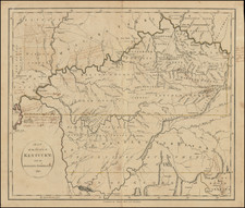
Luke Munsell (1790-1854) was one of Kentucky's first and most important surveyors. Beginning in 1814, he began to compile what would become the first large format map of the Commonwealth of Kentucky. In this same time frame, the United States was in the process of acquiring lands from the Chickasaw nation which would be open to settlement within both Kentucky and Tennessee. In the spring of 1817, anticipating a dispute with Tennessee over the establishment of a border dividing territory acquired from the Chickasaw, the Kentucky legislature paid Munsell to publish "an elegant map" of the Commonwealth. His work resulted in the first large scale map of Kentucky since John Filson's map of 1784. Munsell's map was published on December 16, 1818, utilizing among other information the Jackson-Shelby Treaty with the Chickasaw for the western most portion of the Kentucky-Tennessee border.
Following the completion of the Alexander-Munsell Line survey, the line would ultimately be contested by Tennessee and not formally adopted and would remain in dispute until the 1830s. Among other issues, it was recognized that the Walker Line had not continued on a due westerly course but in fact strayed about 17 miles north at its terminus on the Cumberland River, giving Tennessee about 2,500 square miles of territory which should have gone to Kentucky. Acknowledging this issue on February 2, 1820, the two states resolved to undertake a resurvey, which would last until 1833.
Between 1819 and 1833, several teams of surveyors, including Luke Munsell on behalf of Kentucky on several occasions, meticulously surveyed the modern border lands. In several instances, local adjustments to the border were agreed to, in order to respect the rights of local citizenry, requiring curious minor deviations to respect the wishes of those impacted by the laying of the line.
Following the completions of the surveys, Munsell began work on a new and improved map of Kentucky, which he completed in 1834. "Engraved by Doolittle & Munson, Cincinnati, assisted by Wm. Haviland" and "Entered according to Act of Congress, in the year 1834, by Luke Munsell, in the Clerks Office of the District Court of Kentucky." The map was advertised for sale in the The Western Monthly Magazine, and Literary Journal, as follows:
A MAP of KENTUCKY, reduced from Dr. Luke Munsell’s large map of 1818. Improved to the present time from authentic documents, by the author. Published by Corey & Fairbank, Cincinnati; and L. Munsell, Danville, Ky. 1834.
THE large map of Kentucky, published by Dr. Munsell, in 1818, was compiled with great care, and was the only valuable one then in existence. The variety of alterations occurring in consequence of the rapid growth of the country, having rendered it expedient to publish a new edition, the very elegant production which is now before us, has been prepared. We have examined it with pleasure, and with no small degree of pride, as a specimen of the arts highly honorable to our country. Planned and prepared by a citizen of Kentucky, and executed in Cincinnati, it is an accurate and beautiful work, which would do credit to the best eastern artists. The state is laid off into counties, which are neatly colored; and the margin contains plans of Louisville, Frankfort, Lexington, and Maysville; statistical tables showing the population of every county, a profile of the Lexington and Frankfort rail road, a view of the locks of the Louisville and Portland canal, a. table showing the comparative length of the rivers, and a handsome engraving of the statehouse in Frankfort. It is such a map as every gentleman in the commonwealth should possess—its accuracy being such as to ensure its usefulness, while its beauty renders it a very elegant ornament for the study or the parlor.
Rarity
OCLC locates 2 examples of the 1834 (Kentucky State Archives and University of Chicago) edition and 2 examples of the 1835 edition (British Library and University of Kentucky). Jay Lester notes that examples may also exist in the National Archives and Library of Congress, as well as a copy at the Filson Society.