|
||

|

|
|

|
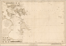
Extremely rare English sea chart, covering some of the far southern portions of Burma, present-day Myanmar, along its Andaman Sea coastline.
The map focuses on the large archipelago that sits off of Mergui, present-day Myeik, near the border with Thailand.
Detailed coastal profiles occupy the top of the map.
Rarity
This chart is of the utmost rarity; we find no other copies ever having appeared on the market, nor can we find another copy anywhere else.
The English mapmaker William Herbert (1718-95) traveled to India in about 1748 as a purser's clerk. Herbert's cartographic publishing started to take form in the late 1740s, when he set up a map and print shop on London Bridge. In 1758, with the encouragement of the East India Company, he introduced a new pilot guide, A New Directory for the East Indies. Herbert gathered superior sources than those used in Mount & Page's The Third Book, consulting such works as Mannevillette's Neptune Oriental, as well as the navigator William Nicholson and the cartographer Samuel Dunn. He often worked with colleagues, including Jefferys, Sayers, Dury, and Andrews, and is recorded as a seller of the famous Anti-Gallican map. In 1776 he retired, having apparently made a fortune. His business was carried on by Henry Gregory Sr.
![[ Indian Ocean - Sailing to Batavia ] Route Exacte De Gamron a Batavia et de Batavia a Gamron](https://storage.googleapis.com/raremaps/img/small/44380.jpg)
![[Straits of Malacca, Sumatra, Java and Western Borneo]](https://storage.googleapis.com/raremaps/img/small/51765.jpg)