|
||

|

|
|

|
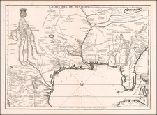
Detailed map of the Carolinas, from Moll's Geography.
The map extends from the Appalachians and Cape Charles to the B. St. Matheo and May River, centered on Charleston and Cape Fear.
The note below the title provides an explanation of the Carolina claim from the Atlantic to the Pacific Ocean.
The English Claim the Property of Carolina from Lat. 29 &c. Degrees as part of Cabot's Discoveries who set out from Briston in 1498, at the Charge of King Henry ye 7th but they did not take Possession of that Country till King Charles the II's time in 1663 who Granted a patent to divers Persons to plant all the Territories within the North Lat. of 31 to 36 Deg. and 50 west in a direct line to the South Sea.
A fine example of this desirable early map of Carolina.
Herman Moll (c. 1654-1732) was one of the most important London mapmakers in the first half of the eighteenth century. Moll was probably born in Bremen, Germany, around 1654. He moved to London to escape the Scanian Wars. His earliest work was as an engraver for Moses Pitt on the production of the English Atlas, a failed work which landed Pitt in debtor's prison. Moll also engraved for Sir Jonas Moore, Grenville Collins, John Adair, and the Seller & Price firm. He published his first original maps in the early 1680s and had set up his own shop by the 1690s.
Moll's work quickly helped him become a member of a group which congregated at Jonathan's Coffee House at Number 20 Exchange Alley, Cornhill, where speculators met to trade stock. Moll's circle included the scientist Robert Hooke, the archaeologist William Stuckley, the authors Jonathan Swift and Daniel Defoe, and the intellectually-gifted pirates William Dampier, Woodes Rogers and William Hacke. From these contacts, Moll gained a great deal of privileged information that was included in his maps.
Over the course of his career, he published dozens of geographies, atlases, and histories, not to mention numerous sheet maps. His most famous works are Atlas Geographus, a monthly magazine that ran from 1708 to 1717, and The World Described (1715-54). He also frequently made maps for books, including those of Dampier’s publications and Swift’s Gulliver’s Travels. Moll died in 1732. It is likely that his plates passed to another contemporary, Thomas Bowles, after this death.