|
||

|

|
|

|
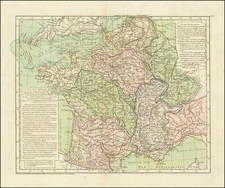
The Third Modern Map of France.
Very scarce etched and engraved map of France, published in the 1507 edition of the Rome Ptolemy Atlas.
The map is a marked improvement from the Ptolemy-based map of the earlier editions, adding islands, topography, many more towns, and in general much more accuracy and detail.
Before the publication of this map, the majority of printed maps of France in circulation were those derived from Ptolemy, whose cartography was by this point, over 1300 years old.
The group of modern maps to which this map belongs represented the first wave of modern cartography overtaking the Ptolemaic tradition that dominated the birth of printed maps. While it is commonly accepted that new maps did not appear until 1513, this represents only the predominance of modern mapping. It appears that most prior atlases had at least some modern mapping.
The New Maps in the 1507 Rome Ptolemy
The new edition of the 1507 Rome Ptolemy adds the following maps to the previous compliment:
1. Universalior Cogniti Orbis Tabula. Ex Recentibus Confecta Observationibus
4. Tabula Moderna Prussi Livoni Norvegi Et Gotti Datia
6. Tabula Moderna Hispanie - Hispania
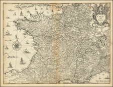
8. Tabula Moderna Francie - Francia
10. Tabula Moderna Polonie Ungarie Boemie Germanie Russie Lithuanie - Germania.
13. Tabula Nova Italia - Ita[l]ia Corsica Insula Sardinia Insula.
26. Tabula Moderna Terrae Sanctae
Rarity
The new maps that were included in the 1507 Ptolemy are necessarily rarer than those that were included in the earlier editions. While we have had the 1478/1490 map of France several times, this is the first time we have had the modern map. Furthermore, this is the first time we have seen any example of the map on the market.
Claudius Ptolemy (fl. AD 127-145) was an ancient geographer, astronomer, and mathematician. He is known today through translations and transcriptions of his work, but little is known about his life besides his residence in Alexandria.
Several of his works are still known today, although they have passed through several alterations and languages over the centuries. The Almagest, in thirteen books, discusses astronomy. It is in the Almagest that Ptolemy postulates his geocentric universe. His geometric ideas are contained in the Analemma, and his optical ideas were presented in five books known as the Optica.
His geographic and cartographic work was immensely influential. In the Planisphaerium, Ptolemy discusses the stereographic projection. Perhaps his best-known work is his Geographia, in eight books. However, Ptolemy’s ideas had been absent from western European intellectual history for roughly a thousand years, although Arab scholars interacted with his ideas from the ninth century onward.
In 1295, a Greek monk found a copy of Geographia in Constantinople; the emperor ordered a copy made and the Greek text began to circulate in eastern Europe. In 1393, a Byzantine diplomat brought a copy of the Geographia to Italy, where it was translated into Latin in 1406 and called the Cosmographia. The manuscript maps were first recorded in 1415. These manuscripts, of which there are over eighty extant today, are the descendants of Ptolemy’s work and a now-lost atlas consisting of a world map and 26 regional maps.
When Ptolemy’s work was re-introduced to Western scholarship, it proved radically influential for the understanding and appearance of maps. Ptolemy employs the concept of a graticule, uses latitude and longitude, and orients his maps to the north—concepts we take for granted today. The Geographia’s text is concerned with three main issues with regard to geography: the size and shape of the earth; map projection, i.e. how to represent the world’s curve proportionally on a plane surface; and the corruption of spatial data as it transfers from source to source. The text also contains instructions as to how to map the world on a globe or a plane surface, complete with the only set of geographic coordinates (8000 toponyms, 6400 with coordinates) to survive from the classical world.
![[ France ] Galliae seu Franciae Tabula, qua omnes Provinciae, Viae angiariae, et aliae res notatu dignae distincte et accurate ostenduntur . . .](https://storage.googleapis.com/raremaps/img/small/98436.jpg)