![[ Patagonia / Chile / Argentina ] A New Map of the Southern Parts of America taken from Manuscript Maps made in the Country and a Survey of the Eastern Coast made by Order of the King of Spain. By Thomas Kitchin](https://storage.googleapis.com/raremaps/img/small/100772.jpg)


|
||

|

|
|

|
A Rare Separately Published Example From A Storied English Country Mansion.
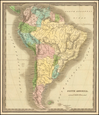
Striking two-sheet, engraved map of South America below the Rio de La Plata, produced by Thomas Kitchin in London in 1772.
Attractively-engraved by Kitchin, the map features an elaborate cartouche with two Patagonian natives, armadillos and anteaters, and local dwellings all depicted. The map pays particular attention to issues of relevance to native Patagonians, including where tribes bury their dead, gather salt, etc. It also elaborates divisions of the Aónikenk people, here called the Tehuelche.
The map also illustrates the "Indian Boundary agreed upon in the Year 1740".
Most copies of the map are found bound into Thomas Falkner's A descripton of Patagonia, and the adjoining parts of South America... (1774). Falkner trained as a doctor before converting to Catholicism, becoming a Jesuit missionary, and moving to South America. Remained there for 38 years, until the expulsion of the Jesuits from South America in 1768. Upon his return to England, Falkner's account of South America was published and became an indespensable work on the continent. Charles Darwin consulted while on the Beagle.
The map imprint line reads: Publish'd as the Act directs, Decr. 10. 1772. and sold by Thos. Lewis, Bookseller, in Russell Street, Covent Garden.
Rarity
While Falkner's book appears occasionally on the market, this is the first time we have ever seen a separately published example of the map on thick paper with wid margins. The map was almost certainly acquired a member of the Berkeley Family in 1772 and remained at Spetchley House until it was sold by Sothebys in December 2019.
Provenance: Sothebys December 2019: Treasures from the Berkeley Family / Spetchley House, in Worcestershire, UK. Spetchley House and Spetchley Park Gardens, now a public museum was home to the Berkeley Family for more than 400 years. It has played a significant role in British history, including being the planned location during WWII of Winston Churchill and his Cabinet in the event London had been lost.
Thomas Kitchin was a British cartographer and engraver. Born in Southwark, England, Kitchin was the eldest of several children. He was apprenticed to the map engraver Emanuel Bowen from 1732 to 1739, and he married Bowen’s daughter, Sarah, in December 1739. By 1741 Kitchin was working independently and in 1746 he began taking on apprentices at his firm. His son Thomas Bowen Kitchin was apprenticed to him starting in 1754. By 1755 Kitchin was established in Holborn Hill, where his firm produced all kinds of engraved materials, including portraits and caricatures. He married his second wife, Jane, in 1762. Beginning in 1773 Kitchin was referred to as Hydrographer to the King, a position his son also later held. He retired to St. Albans and continued making maps until the end of his life.
A prolific engraver known for his technical facility, clean lettering, and impressive etched decorations, Kitchin produced several important works throughout his career. He produced John Elphinstone’s map of Scotland in 1746, and the first pocket atlas of Scotland, Geographia Scotiae, in 1748/1749. He co-published The Small English Atlas in 1749 with another of Bowen’s apprentices, Thomas Jefferys. He produced The Large English Atlas serially with Emanuel Bowen from 1749 to 1760. The latter was the most important county atlas since the Elizabethan era, and the first real attempt to cover the whole country at a large scale. In 1755 Kitchin engraved the important John Mitchell map of North America, which was used at the peace treaties of Paris and Versailles. In 1770 he produced the twelve-sheet road map England and Wales and in 1769–70 he produced Bernhard Ratzer’s plans of New York. In 1783, he published The Traveller’s Guide through England and Wales.
![Oceani Occidentalis Seu Terrae Novae Tabula [The Admiral's Map]](https://storage.googleapis.com/raremaps/img/small/102935.jpg)