|
||

|

|
|

|
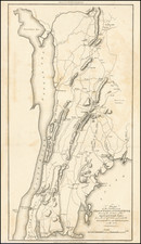
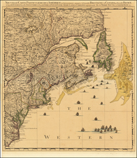
Second Earliest Earliest American Map to Show Post Roads in the Colonies
Finely executed regional map of the Northeastern United States, illustrating the American Postal Road System in the British Colonies.
Homann's map is drawn from the first state of Herman Moll's map of the same region, which appeared in Moll's Atlas Minor, and is generally regarded as the earliest map to show the post roads in America.
The first state of the Moll's map included the earliest depiction of the post roads in America, with a detailed explanation of the operating postal routes in America, the first American map to describe and depict mail service in the British Colonies in North America.
In the first state of Moll's map (1729), the note at the bottom right appears, but only a single route from Philadelphia to Boston and on to Piscataway is shown. In the second state, a road from New York to Albany and on toward Lake Ontario is shown, and the main route now extends west to Lancaster, before splitting into two routes headed further west.
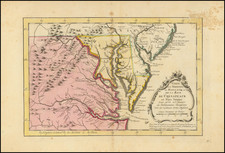
A seminal antique map of the British Colonies in America.
Johann Baptist Homann (1663-1724) was a mapmaker who founded the famous Homann Heirs publishing company. He lived his entire life in Bavaria, particularly in Nuremberg. Initially, Johann trained to become a priest before converting to Protestantism and working as a notary.
In 1702, Johann founded a publishing house that specialized in engravings. The firm flourished, becoming the leading map publisher in Germany and an important entity in the European map market. In 1715, Johann was named Imperial Geographer to the Holy Roman Empire by Charles VI and made a member of the Prussian Academy of Sciences. Most importantly for his business, his reputation and contacts gained him imperial printing privileges which protected his publications and recommended him to customers. Johann is best known for this Grosser Atlas ueber die ganze Welt, or the Grand Atlas of the World, published in 1716.
After Johann died in 1724, the business passed to his son, Christoph (1703-1730). Upon Christoph’s early death, the company passed to subsequent heirs, with the name of the company changing to Homann Erben, or Homann Heirs. The firm continued in business until 1848.