This item has been sold, but you can enter your email address to be notified if another example becomes available.


|
||

|

|
|

|
Stock# 64679
Description
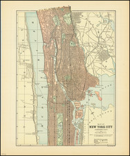
Detailed early subway map of Manhattan, Brooklyn, Queens, and the Bronx.
The map sports a large inset photograph labeled: S.S. Conte Grande (The Great Count) and S.S. Conte Biangamano (The White County) "Fast Passenger Service to the Mediterranean".
The map was given as a promotion for the Lloyd Sabaudo passenger line.
The map was probably issued between 1927 and 1932. In 1927, the Dornier Do R Superwal flying boat (illustrated on the covers) was introduced in commercial service. In 1932, the Lloyd Sabaudo merged to become the Italian Line. It was probably made around 1927, as the George Washington Bridge is shown as "Proposed" and construction began on it in 1927.
Condition Description
Old folds. Minor stain in the Upper East Side and East River. Original paper covers.
![[2 Maps / Midtown, Manhattan] Map of Real Estate in the 12th Ward of the City of New York Belonging to the Estate of Jacob Harsen, Decd.](https://storage.googleapis.com/raremaps/img/small/58778.jpg)
![(American Revolution) [Manuscript Map of New York City and Northern New Jersey]](https://storage.googleapis.com/raremaps/img/small/69609.jpg)