The item illustrated and described below is sold, but we
have another example in stock. To view the example which
is currently being offered for sale, click the
"View Details" button below.


|
||

|

|
|

|
Stock# 64669
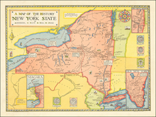
Description
EArly pictorial map of New York State, published by R.R. Bowker in New York.
The map provides a history of the state, covering a period of 400 years, including:
- Giovanni da Verrazzano's discovery of New York Bay in 1524
- Dutch settlements of the early 17th century where Peter Minuit bought the island of Manhattan for 60 guilders
- completion of the Erie Canal in 1825
Includes insets of "Old New York", "Niagara" and "Two Great Rivers." Decorated by five coats of arms and an attractive compass rose.
Created by Alexander Flick and Paul Paine.

![[Maximum Berkeley] A Map of Berkeley, Oakland & Alameda](https://storage.googleapis.com/raremaps/img/small/50325.jpg)