|
||

|

|
|

|
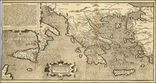
Rare Map of the Western Mediterranean
Finely executed map of the western Mediterranean and environs, published to illustrate the work of French traveler and writer Aubry de la Motraye.
As a result of the religious persecution that struck the Protestants in France at the end of the 17th century, Motraye moved to England. Beginning in 1695, he made several trips in the Mediterranean and the Ottoman Empire . In June 1711 he was introduced to Charles XII, the King of Sweden, who was then living in exile in Ottoman Bender, following Peter the Great's invasion of Sweden. Motraye thereafter wrote an in-depth description of the King's and the other Swedes' camps in Bender, the captivity in Demotika and the return to Sweden.
In 1720, Motraye returned to England, where for a few years he was engaged in drafting a manuscript on his travels. The work was published in English in 1723 under the title Travels through Europe, Asia and into part of Africa, illustrated with engravings by William Hogarth . In 1727, a French version was published, with partly different content.
During the 1720s, Motraye made further trips in Europe, which he also described in book form.
![[Signed Political Satire Artwork] Vietnam ... Vietnam ... Vietnam ...](https://storage.googleapis.com/raremaps/img/small/68726.jpg)
![[ First English Sea Chart of Europe ] A Generall Carde, & discription of the Sea Coastes of Europa, and navigation in this booke conteyned](https://storage.googleapis.com/raremaps/img/small/51688.jpg)