|
||

|

|
|

|
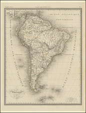
9 Sheet Hand Colored Photofacsimile
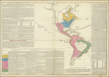
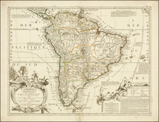
Facsimile image of Cruz Cano y Olmedilla map of South America, the most important printed map of South America published in the 18th Century. As described below, production of the map had been commissioned initially by Thomas Jefferson in 1786, although for poltical reasons it had been delayed for nearly a decade. With Britain and America each encouraging revolution in South America in the late 1790s, production of the map became an object of discussion among many important poltical figures in England and America, with the final preparations for publication of the map actively pursued by Francisco Miranda and tracked in correspondence by Alexander Hamilton, James Madison, among others.
This remarkable map was originally drawn by Juan de Cruz Cano y Olmedilla under the direction of the Spanish government and is based on cartographic material of Consejo de Indias, Jose de Ayala and the reports of the Jesuits and other missionaries in South America. Juan de la Cruz spent ten years collecting measurements made by explorers and colonists and incorporated in the map valuable geographical and historical news, with some references to the sources used. Measuring approximately 6 x 8 feet, the Cruz Cano map is probably the most important map of South America made in the 18th century. The purpose of the map was to delineate the boundary between Spanish and Portuguese colonies.
As noted by Smith:
In spite of the fact that it was an official project, initiated and paid for by the Spanish Government, it appears to have been withheld from public distribution for a quarter-century following the first printing in 1775. Consequently, it was seldom on the market. Thomas Jefferson and Alexander von Humboldt were both authorities for the statement that the plates had been destroyed. In the years immediately following its appearance and on several occasions during the next century the merits
The map is by far the most precise and complete map of South America and considerably more accurate than any map of North America from this period. It was used in several treaty negotiations during the 19th century, particularly between Brazil and Argentina in 1894. While it was believed that the original plates were destroyed, Smith, in his excellent work on the map, notes that the plates were in use well into the 19th Century.
A later edition by John Faden was created in 1799. The Faden edition of the map is discussed by Jeanette Black in Linea Del Castillo, wherein she discussed the changes made by Faden from the original Cruz Cano map as follows:
Explaining the erasure of [the] embellishments from [Faden's] 1799 re-engraving requires a little historical context. Thomas Jefferson sent his third edition of America Meridional to London via the United States diplomatic corps for re-engraving late in 1786. Spain's refusal to allow wider dissemination of this map, postponed the project. By the 1790s, Spain had allied with France against Great Britain and the United States, changing the geopolitical playing field. In August 1798, the US diplomatic corps in London charged pro-independence Spanish American patriot Francisco Miranda with overseeing British mapmaker William Faden's re-engraving. Armed with this geographic vision of South America, Miranda called on British and US diplomats to "wreak the greatest possible injuries upon their enemies" by detaching from Spain an immense, wealthy and heavily populated dominion that could "by a counter stroke be turned to France's advantage." It should therefore not come as a surprise that Faden's 1799 printing omitted the portions of the [Cruz Cano Map] that heralded Spanish imperial control over South America. For not only did Britain and the United States covet this region; so, too, did pro-independence Spanish Americans like Miranda.
Thomas Jefferson's Commission of Faden's Map of South America
As noted above, In 1786, while serving as minister to France, Thomas Jefferson received Cruz Cano's map of South America from William Carmichael and sought to have copies made for himself and Congress. Jefferson enlisted William Stephens Smith, John Adams's son-in-law who was then living in London, to help him commission the London mapmaker William Faden to make these copies. In a letter to Smith, Jefferson described the map and its importance:
The government of Spain at first permitted the map, but the moment they saw one come out, they destroyed the plates, seized all of the few copies which had got out and on which they could lay their hands, and issued the severest injunctions to call in the rest and to prevent their going abroad. Some few copies escaped their search. A friend has by good management procured me one, and it is arrived safe through all the searches that travelers are submitted to.
Sight unseen, Faden agreed to reproduce all twelve sheets of the map. In December 1786, Jefferson sent the map to Faden in care of Smith, and drew up a set of suggestions for republishing the map, including three sketches of the proposed layout of the sheets.
Alexander Hamilton and others Press For The Completion of The Faden Map
In a letter addressing the prospects of Revolution in South America from Rufus King to Alexander Hamilton dated October 20, 1798, King updates Hamilton on the status Francisco Miranda's efforts to secure the production of the map, as part of the broader effort to foment Revolution in South America and enlist British support. King writes: ". . .fortunately some months past I obtained a facsimile of the latest map of the Country. It has been now two months in the Hands of an Engraver, who has engaged to deliver Copies in January."
As scheduled, on January 1, 1799, Faden finally published his copy of Cruz Cano's work, but he neither sent Jefferson the copies he requested nor returned the original. Jefferson, who had enlisted friends such as James Madison to inquire as to Faden's progress, resorted to buying a copy from a London map dealer in 1805, some nineteen years after sending the original to Faden.
Juan de la Cruz Cano y Olmedilla (1734-1790) was a Spanish cartographer and geographer. Initially trained in Madrid, he was sent to Paris with another promising student, Tomas Lopez de Vargas Machuca, to study under Jean Baptiste Bourguignon D'Anville. They worked together on a map of the Gulf of Mexico, published in 1755. Cano y Olmedilla is best known for his monumental eight-sheet map of South America (Mapa Geografico de America Meridional), published in Madrid in 1775 and made at the bequest of the Marquis de Grimaldi. Cruz Cano y Olmedilla's name appears on a number of other maps and charts published in eighteenth-century Spain, most notably on the maps in Torfino de San Miguel's Atlas Maritimo de Espana.